Thursday, July 31, 2008

Custer State Park, South Dakota, July 30, 2008


Roaming bison, trout-filled mountain streams, granite peaks that soar to the sky, the howl of a coyote on a starry night!! Custer State park covers 71,000 acres in South Dakota's Black Hills.

Custer State Park is named for George A. Custer, who lead a scientific army expedition into the Black Hills in 1874. Though the expedition discovered gold, Custer seemed more interested in the area's uncommon natural beauty.

In 1913, the South Dakota legislature created a state game reserve in the southern Black Hills. In 1919, the reserve became Custer State Park.

When we were here last year we travelled the 18-mile Wildlife Loop road in search of bison. We did not see one! Not one! So on Tuesday, July 29, early in the morning, as that

is the best time to see the wild life along the loop we headed off once again in search of the elusive bison, and the only bison we did catch a glimpse of were a few way off behind some trees. We continued along the road and saw burros and elk and prairie dogs, but no bison...

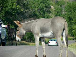
In the park you may not find the bison, but the Park's wild burros will find you! These panhandling jackasses are perpetually hungry! While one of them blocks traffic, his buddies conduct a car-to-car search, hoping for some cookies or crackers to eat. Find them, we did, but no bison!

At the end of the road we decided to turn around and see if we could find them...so back we went. We stopped at the visitor station and they said they had been seen along the off road, 4 Mile Draw Road.. so off we headed but when we got to the road it was closed...

Back at the beginning of the road we decided to head south on highway 87 and when we rounded the bend.........................................

see below.............................
Posted by Picasa

Bison, Custer State Park, July 30, 2008


There in the road were the Bison!!! All over the place, blocking traffic, a huge heard of the giant animals!!!

There are nearly 1600 buffalo in the park and they are allowed to roam free. The signs all say not to approach the buffalo.....but what if they approach you??? There were several young males that looked like they were playing and I thought that for a moment that they might run into the car... but they stopped short.

When you get caught in a "buffalo jam," it is best to just relax and enjoy the spectacle of the bison crossing the road. Eventually, they will move.

Funny, we have driven the Wildlife Loop Road 3 times and not one bison and you travel down the main highway and there they are!!!!! Well, I have now seen them up close and personal.
As you can see there are calves along with the adults . We stayed there watching them for quite a while and then saw more coming up the highway so we decided to turnaround and head back to the RV.

What a sight!!! Worth the trip!!

Well, we are off on Friday once again... will check in later to let you know where we have landed.... Until then,

Candy and Johnny
Posted by Picasa

Devils Tower, Wyoming, July 29, 2008

On Tuesday, July 29, we drove over to Devils Tower in Wyoming. We did not stop there last year when we were in the area. You have to see it to believe it. Rising 1,280 feet above the eastern plains of Wyoming and the Belle Fourche River. It is truly a one-of-a-kind natural wonder! The two-square-mile park surrounding the tower was proclaimed the nation's first national monument by President Theodore Roosevelt in 1906. Devils Tower is steeped in Native American tradition. One legend has it that a giant bear clawed the grooves into the mountainside while chasing several young Indian maidens.

In case you can't quite remember why it looks so eerily familiar, it's because Devils Tower played a pivotal role in the climax of Steven Spielberg's si-fi classic " Close Encounters of the Third Kind".

Rock climbing is the favorite sport at Devils Tower. We saw two teams... one ascending (see bottom photo) and one descending the tower. That would not be me as I have a terrible fear of heights!!!! We did hike the 1.3 miles around the base which winds among rockfalls of gigantic columns which have fallen from the monolith.

It truly was an amazing sight!

That is all for today.

Have a great summer,

Candy and Johnny
Posted by Picasa

Wednesday, July 30, 2008

South Dakota, July 25, 2008

Greetings! We left Estes Park on Friday, July 25 and headed to South Dakota. It was a nice

drive and once again the weather was great. We are staying at the Rafter J RV Ranch near the town of Hill City. Hill City, like most Black Hills towns, grew out of the great gold rush in the 1800's. The little town is centrally located in the region, set smack-dab midway between the world famous mountain carvings of Mount Rushmore and Crazy Horse in a picturesque mountain valley.

We found a small winery in town called the Prairie Berry. Their wines are made from some grapes but mostly from berries and fruits native to South Dakota.
They are getting ready for the Sturgis Bike Rally here next week. There are bikes everywhere. We did not go over to Sturgis but like Daytona one area is not large enough to hold everyone so the area is full!!!


When we left the city we ventured up to Mount Rushmore. We entered the area at Custer State Park, near Sylvan Lake Lodge. Rich in history and natural beauty, Sylvan Lake (top photo) holds the designation as Custer State Park's crown jewel. the lake was created in 1881 when Theodore Reder built a dam across Sunday Gulch.In 1921, this unique lake became a part of the newly-created Custer State Park.

Along the highway through Custer State Park to Mount Rushmore there six tunnels along the winding roads, they range in size from 14'0" Wide 12'9" High down to 8'4" Wide 12'0" High. One tunnel near Sylvan Lake is 10'6" Wide and 10'7" high. Needless to say, we did not take the RV on this trip. We did see a tour bus coming through one of the tunnels. it was a very tight squeeze to say the least.

South Dakota, July 25, 2008

We finally came upon Mount Rushmore. We did not go to the Visitors Center, as we had been there last year when we were here. We learned all about Gutzon Borglum and his historic masterpiece. I have to say that this is a very impressive sight!! The most spectacular program at Mount Rushmore is the evening lighting ceremony held in the amphitheater at 9 P.M. nightly. A ranger introduces a 20-minute movie on Borglum and his mountain and then, with the strains of the "Star Spangled Banner" in the background, huge banks of floodlights dramatically reveal the four presidential faces, stark white against the black, starry Dakota sky.


The colossal Crazy Horse mountain carving in progress is the world's largest sculpture. The memorial is a tribute to the North American Indian. The carving was first conceived as a vision of Boston-born sculptor Korczak Ziolkowski in 1939. The sculptor had received a letter from Henry Standing Bear, a Lakota Sioux Indian Chief from South Dakota. Standing Bear had been watching progress on the American Presidents at Mount Rushmore, and he longed for an equally powerful memorial that would remind the world "that the Red Man has great heroes, too".

Korczak went to work creating his 563x641 foot sculpture on June 3, 1948. He would spend the next 36 years of his life blasting away 7,400,000 tons of granite to rough out virtually the entire figure, in the round. Progress was painfully slow. Unlike Mount Rushmore, which used a big crew it was just Korczak - and later Korczak and his sons.

Korczak died in 1982 with the mountain only roughed in, but he passed along to his wife and their 10 sons and daughter his vision and passion for his mountain.

The 88-foot-high face of Crazy Horse was dedicated on June 3, 1998, 50 years to the day after Korczak's first blast. Now, 60 years after Korczak started carving, and 26 years after his death, work still continues on the world's largest sculpture. The dimensions are staggering. A mountain-sized statue of an Indain man and a spirited warhorse that's as long as a cruise ship and taller then a 60-story skyscraper!

Work continues on the mountain every day. From time to time you get to witness the sight, sound, and concussion of a blast, a glimpse of history in the making. When will the Memorial be finished? It's impossible to say.

Well that is all for now.... Hope all is well with everyone.... Love,

Candy and Johnny

Thursday, July 24, 2008

Valluvial Fan, RMNP July 24, 2008

This morning we went to an area in Rocky Mountain National Park known as Valluvial Fan.
Once there you see a large scarred area of huge rocks. This is called The Alluvial Fan and is the result of the Lawn Lake Flood of 1982.
On July 15, 1982 at 5:30a.m., Lawn Lakes earthen dam failed, releasing 29 million gallons of water. As the flood rushed downhill four miles to this point, the surging waters picked up boulders and snapped trees. A trash collector heard the waters crashing down Roaring River and called the park Rangers.

It is difficult to imagine that rushing water can move such large boulders.

Tomorrow we are heading toward South Dakota and Mount Rushmore. We will be there for about a week.

More later,

Candy and Johnny

Posted by Picasa

Drive to Lake Grand, July 23, 2008

Another day, another day trip. Today we are going to take a trip over to Grand Lake. Once again we find ourselves taking the Trail Ridge Road up to the Alpine Visitors Center and down the other side toward Grand Lake. The Trail Ridge Road is the highest continuous paved road in the United States.

When we departed Estes Park it was a lovely clear day. However as the sighs say along the way...the weather is subject to change at any time, and change it did!! As we ascended the mountain the temperature began to drop and the sky turned dark. As we neared the 12,000 foot level the temperature had gone from 85 degrees to about 50 degrees and as you can see from the top photo, the rains had begun. By the time we had begun our travel down to Grand Lake, the temperature dipped to a low of 44 degrees. With thunder and lighting around us it was an

impressive sight!

As we travelled down towards the Village of Grand Lake, we went through Milner Pass, which is the continental divide where the mountain summits divide the flow of water wither to the east or to the west.

As we continued on we found some moose grazing in the meadow. They are huge animals and can be very dangerous. It seems that more people are killed by moose each year than from bears.

The village of Grand Lake is surrounded by Shadow Mountain, Grand Lake, Rocky Mountain National Park and the Arapaho National Recreation Area. This small western type town has some interesting shops and we were told is as vibrant in the winter as in the summer. Just as we got out to walk around the rains came again, this time with some hail that was about pea size. We ran into a shop to get out of the weather and bought some jerky, elk. It was very good as they were handing out samples.

At the rain did not look like it was going to stop soon we headed back up to mountain and back to Estes Park.

That is all for today.

Miss you all,

Candy and Johnny
Posted by Picasa

Alberta Falls and Bear Lake, RMNP, July 22, 2008

July 22, and once again we were off to Rocky Mountain National Park. This time we headed to the park and ride along the Beaver Meadows Trail to take the free shuttle to the Glacier Gorge Trail Head for a hike to Alberta Falls. The lovely 25-foot high cascade in Glacier Creek is the most popular waterfall in the park. It is also a relatively easy hike along a moderate, well-maintained trail. The distance from the trail head in 0.8 miles. The elevation is 9,180 feet and the elevation gain along the trail is 220 feet. It was a beautiful place to sit and watch the cold ice melt flowing down the mountain.

From here we hiked back to the tail head and then headed up to Bear Lake. It was a 0.5 mile hike and as we discovered later a 330 foot gain in elevation!! John kept telling me that it was an easy hike, but I was not convinced... but I made it to the top.. only to find out that I could have gone back to the Glacier Gorge Trail Head and taken the shuttle up to the Bear Lake Trail Head. Oh well, It was a beautiful hike. From here it was a beautiful hike around Bear Lake, a 0.5 mile walk with only a 20 foot gain in elevation! I like that much better! Bear Lake is a beautiful clear lake with Hallet's Peak in the background. The lake has been a success story in the propagation of the native Greenback Trout, which at one time was an endangered fish species.
There is always so much to see and learn here in the park. I think you could spend all summer here and never see or learn it all!

We have several more days here and then we are off again... until later.

Candy and Johnny
Posted by Picasa

Monday, July 21, 2008

Drive to Nederland, Colorado July 21, 2008


Hi all, we took Sunday off to get some laundry done and generally just hang out for the day. We did have some small showers in the afternoon. Monday dawned to a glorious day and we decided to take off once again. (Guess I just can't get enough photos of "rocks"!)

The middle photo is of St. Catherine of Siena Chapel. We rounded a curve and there it was, sitting on top of a rock. We had no idea exactly what it was so we decided to explore. It is a Catholic Chapel that is part of the St. Malo Retreat Center. It seems that in 1916, Father Joseph Bosetti saw a falling star in the summer sky and in his search to find the crater, he came across a natural wonder: an immense Granite rock in a meadow that held a stunning view of the east face of Mt. Meeker. He looked no further for the meteor. Remembering Jesus' word to Peter, Fr. Bosetti vowed to one day build a chapel on the rock. Twenty years later, on that spot his dream was fulfilled and a lovely stone chapel was dedicated under the patronage of St. Catherine of Siena in 1935.

In 1993 Pope John Paul II visited the chapel during his trip to Denver for the World Youth Day and bestowed his personal blessing on the chapel.

The sanctuary lamp has been in use in this chapel since the first Mass was offered in 1935. Before its arrival in Colorado, the antique lamp hung in a small chapel in Rome which Mussolini ordered torn down in order to make room to build a road.

The Chapel on the Rock is truly a Colorado landmark and a lovely place to visit.

We continued on our way and ended up in the town of Nederland. We stopped to have lunch at the Bear Brothers Bistro. Lunch was great and the beer was even better. Such a cute little town the mountains.

On the drive back to Estes Park the sky clouded over and we thought we might get wet but we were lucky and made it back with no rain.

That is all for today, Hope all is well with everyone.

Love to all,

Candy and Johnny
Posted by Picasa

Old Fall River Road July 19, 2008


We got to Estes Park, Colorado on Friday, July 18, 2008. It was a short drive from Glenwood Springs, through Boulder. Another pretty drive, following the Colorado River for most of the way.

On Saturday we headed out to Rocky Mountain National Park. We headed up the Old Fall River Road. It was built between 1913 and 1920 and was the first motor route to cross Rocky Mtn. Nat'l Park. In the 9 miles you travel from the montane meadows and woodlands through subalpine forests to the alpine tundra.

Old Fall River Road remains much as it was in 1920. It follows the steep slope of Mt. Chapin, numerous drop offs and hairpin turns on a narrow dirt road. Today, as it was when the road was built, it remains the edge of wilderness.

During the early construction phase, all work was done by 38 convicts from a Colorado state penitentiary. The road was slightly widened and straightened in 1932, following this the road was designated a one-way route.

The journey begins at 8,558 feet above sea level and ends at Fall River Pass, 11,796 feet. As you climb, the temperature cools by roughly 3 to 5 degrees for each 1,000 foot gain in elevation.


At the end of the Old Fall River Road you come to the Alpine Visitor Center Center, built in 1965 by the National Park Service. We stopped here to stretch our leg and have some lunch. There is a path that leads up to the top of the mountain and you reach 2.3 miles above sea level. It was quite a hike up the side of the mountain but we both managed the climb.

From here, we returned via Train Ridge Road back to Estes Park, 25 miles to the east. Along the way back we found several herds of elk grazing along the side of the road. We also saw some yellow bellied marmot. Cute little critters that don't seem to care if you are there or not.

It was a wonderful drive and we stopped several places and hiked the trails to waterfalls and glaciers and rock formations. As I have said before.....INCREDIBLE !!!!

That is all for now.

Miss you all,
\
Candy and Johnny


Posted by Picasa

Sunday, July 20, 2008

Elk Scenic Byway, Glenwood Springs


It was another glorious day on Thursday, July 17th as we headed out once again to tour the mountains. We left Glenwood Springs and back down to Carbondale and from there we turned and headed west this time to Paonia. We passed through the scenic Crystal Valley and then on up to McClure Pass at 8,755 feet. Further on we took a left turn and headed to the Ragglands Wilderness Area. The route passes through pine forests and expanses of aspen. Up up again this time through Kebler Pass at 9,980 feet. During the winter Kebler Pass is closed except to snowmobilers.

As we continue we come to the town of Crested Butte and around to Gunnison. After the mountains, the broad valley between the two towns is an interesting contrast. The open pastures provide ample forage for cattle, deer,and elk. Three dams on the Gunnison River have transformed the semi-arid area into a recreation mecca. The high, dry vistas are now interrupted not only by the Gunnison River's narrow thread, but also by three lakes, Blue Mesa, Morrow Point and Crystal.

Around past the town of Mahr and Crawford we are back at Paonia and then back along Hwy 133 to Redstone and Carbondale and back to Glenwood Springs. We did pass the town of Marble where marble was quarried for many notable structures including the Lincoln Memorial and the Tomb of the Unknown Soldier.

John says that what we really need is a jeep to go through these mountains but I kind of like the convertible with the top down.

Next we are off to Estes Park...so much more to see... what a great big country this is that we live in with so much to see.....
Until later...

Candy and Johnny
Posted by Picasa

Glenwood Springs, Colorado


Monday, July 14 and we were off to Glenwood Springs, Co. We stayed at the Glenwood Canyon RV Resort, right along the Colorado River. The top photo was taken just around the bend along the walk/bike path from the RV park. On the far side of the river are train tracks and trains go by several times a day. The best part is that there are no road crossings so the train whistle is not blowing during the night!. We are parked up on a bluff with a beautiful view of the canyon walls. Another beautiful place to stay and as John says... another opportunity for me to take pictures of more "rocks". But he does like the photos that I take, I wish that I could up-load more of them than can be posted here.

The Historic Hotel Colorado is here is Glenwood Springs and is an icon in the quaint mountain town. In the late 1880's, Entrepreneur Walter Devereux had a vision to create a world-class resort with a grand hotel and therapeutic natural hot springs. The Hotel Colorado made its debut in 1893 attracting visitors from across the globe. For more than 112 years it has been the place of legends. The teddy bear, Teddy Roosevelt's western White House, gangsters, and a World War II U.S. Naval hospital, all have roots here. Because of its cultural significance and commitment to preservation, the National Park Service has recognized the Hotel Colorado on the list of National Register of Historic Places. It has recently undergone a huge renovation

that is still ongoing today.

The world's largest mineral Hot Springs Pool is only steps away, and known for its health benefits. We did not go to the pool but each time we passed the pool was a busy place.

We decided to go out wandering again and to drive around the area. We left Glenwood Springs and headed toward Carbondale and then to Snowmass, Aspen and up through Independence Pass. Independence Pass ( which is closed from November to May) is on the continental divide. As you can see we were are 12,095 feet above sea level . You feel as if you are on the top of the world and the views from here are spectacular in every direction!

As we continued on around on CO-82 we came to Twin Lakes and then headed past Mt. Elbert and up to Leadville. Leadville is a coal mining town and still has mining today. If you saw the movie "The Unsinkable Molly Brown" this is the town where Molly and husband Johnny Brown were from in Colorado. The National Mining Hall of Fame is located here.

As we left Leadville, we headed back toward I-70 and back to Glenwood Springs and our little home away from home. It was a beautiful drive through the White River National Forrest.

There is so much more to see here so we will be off another day, but that is all for now.

Take care,

Candy and Johnny
Posted by Picasa

Saturday, July 19, 2008

Grand Junction/Gateway, Colorado

I am finally getting back to my blogs and I hope that the wifi connection holds for me to post this.

We finally left Moab, Utah on Saturday, July 12 and headed to Grand Junction, Colorado. It was a short drive, only 105 miles. We stayed at the Monument RV Resort for two nights. It was near the Colorado National Monument (top photo). As we decided to go out exploring we discovered that the area has many winery's!! They have some wonderful wines...how fun! We also found the Colorado Wine Tasting Room, where you can go and taste most of the Colorado wines in one place without driving around. We stopped there and tasted several of the wines from winery's that were further away from where we were and then decided to go to some of the winery's near by. We did some tasting and some buying!!!


We also discovered that the Palisade area also grows lots of fruit along with the grapes. John found a small shop along the road where a lady was making fresh baked pies. The one that we brought home was blackberry/raspberry, and it was wonderful!

While in this area we took a side trip down to Gateway, Colorado. Just when we had decided that there was not much there we rounded the bend and in the middle of no place was a huge complex with hotel, spa, ranch and all the amenities. Someone had really put a great deal of money in the place. The ride there through the mountains was beautiful and I am always surprised at all the different scenery that you come upon . The bottom photo was taken just across the road from the rocky cliffs.
On Monday we headed over to Glenwood Springs....I will post more photos and information later. That is all for now. Take care,

Candy and JohnnyPosted by Picasa

Sunday, July 13, 2008

River Raft Trip Friday, July 11,2008

I have the photos! So there can be no doubt.... I was on a river raft trip on the Colorado River!

Yes, I, Candace Kane Badger! I know that my family will never believe this!!! (I am the one in front with the white hat)

What a fantastic ride!! John has been on them before but this was my first time. We took a full day trip that was a 14 mile journey down the river through some 1 to 2+ rapids.
We were on the raft with our guide Becky.
She is a 21 year old student at BYU, but we won't hold that against her! She was great and also the leader of the entire group of 8 rafts, four kayaks and 81 people. As the leader she was to make sure that all went well...and as it turned out we had to help participate in several rescues as

there were several of the kayaks that overturned and the occupants had to be retrieved. All survived and a good time was had by all..I would do it all again!

We began at 8am, stopped for a break along the bank and then down to the Red Cliffs Lodge for a wonderful BBQ lunch and finally were taken out at about 3pm.

Have to say that it was a good way to keep cool in the warm temperatures of the Moab Summer! John went over the side and into the river to cool Posted by Picasaoff but I stayed in the raft as I was wet enough with the water gun fights with the other rafts and water from the rapids.

I am ready to go again!! Next time John wants to take a two or three day trip. I am not sure about that, but never say never!

We are off to Grand Junction, Colorado next so stay tuned for more later...

Until then, Candy and Johnny