Wednesday, July 27, 2011

Mt. Rainier


What glorious weather greeted us upon our arrival in Seattle. John had lived out here for many years while flying for Northwest. He talks about how much it rains here in the great Northwest, however, it is a fact that Seattle gets less rainfall annually than Atlanta, Boston, New York, Houston Miami, New Orleans, Philadelphia and Washington D.C., with 37 inches.

Bright and early on Saturday morning we headed off to Mt. Rainier National Park. Mount Rainier is one of the oldest National Parks, established in 1899. Towering over Puget Sound, Mount Rainier is located 83 miles southeast of Seattle, and is the most beloved landmark in the state. The park's rich forests, waterfalls, glaciers and abundant wildlife offer a variety of outdoor adventures.

Mount Rainier is the highest peak in the Cascade Mountain Range with a summit of 14,410 feet. The "mountain" is an active volcano encased in over 35 square miles of snow and ice and more than 26 glaciers. As an active volcano Mount Rainier stands as a reminder of the beauty and power of nature. The Cascade Range has been volcanically active for millions of years, thanks to its location close to the western edge of the North American tectonic plate. The mountain we see today is relatively young in geologic terms: it formed about 500,000 years ago. Like Mount St. Helens and other volcanoes, Mount Rainier had the potential to erupt again at some unknown time. Volcanologists expect the mountain to give ample warning before entering an eruptive period, but the threat of
unexpected mudflows exists throughout the park.

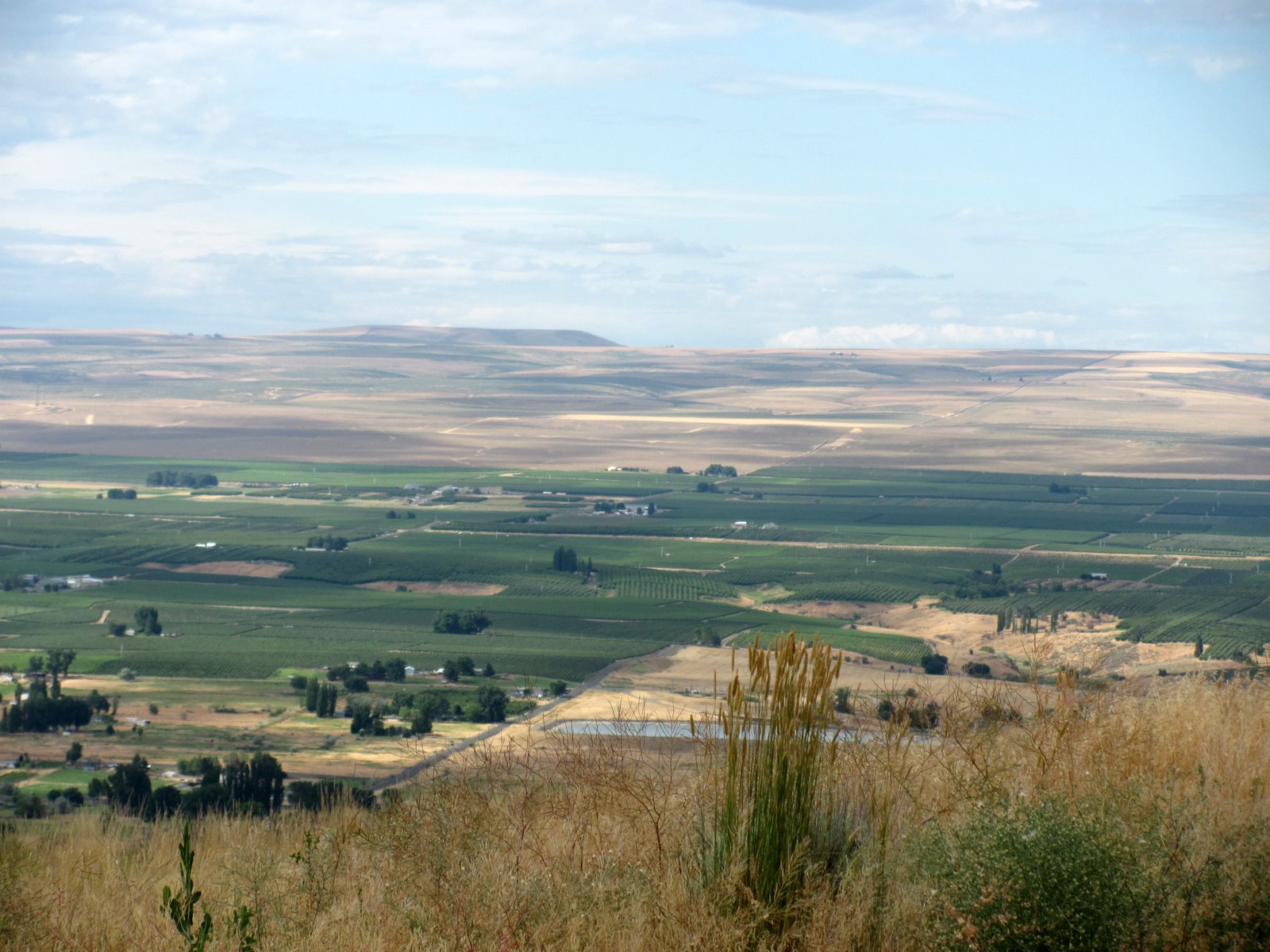
One of our stops for the day was at Crystal Mountain. We took the gondola ride to the top of the ski area (which had just closed skiing the seek prior). The views from there were glorious. As we had arrived early in the day it was like our own private journey. When we had finished our wanderings it was beginning to get more crowded.
We spent the entire day sightseeing and enjoying nature!

I have also discovered several more "fun" facts about Washington State:
-It is the 42nd state to join the Union and is the only state named for a President.
-Father's Day was founded here in 1910.
-"The Wave", a popular fan cheer for the past 25 years, was started by Husky fans at the University of Washington.
-Washington produces 70 percent of the nation's hops used to brew beer. Coincidentally, to overcome beer breath, the majority of the nation's mint is also grown in the state.

We also had dinner with a flight attendant friend, Susan and also had dinner with our friends, Jan and Scott. It is always so wonderful to see friends that we have not seen for awhile, just to talk and share great times!!

We are off to Anacortes for a month or so... more on our stay there later.

Love to all,

Candy and Johnny


Posted by Picasa

Tuesday, July 26, 2011

Washington State, Wine Country

On July 16, we left Post Falls, Idaho after a couple of days of rest, hopped back on I-90 and once again headed west. Washington is called the "Evergreen State". According to the brochure, "this is the state you visit when you want the best of all worlds." I have to admit that no matter where you are or which direction you look, there is an awesome view, either of the magnificent Pacific Ocean, mountain ranges that reach to the heavens, rumble (and sometimes erupt), rivers and their surrounding shrubbery and forests that will take your breath away! The state is the 20th largest state with 66,51 square miles with a population of 6,668,200.
We passed through Spokane and when we hit U.S. 395 turned south toward Prosser, Wa. As we did not make it to Canada, and we have been to the Oregon wine country several times, it was time to try something new.

Prosser is a quiet friendly town surrounded by breathtaking natural beauty. Nestled between the foot of the Horse Heaven Hills and Rattlesnake Hills with the Yakima River running right through the town. Prosser is the "birthplace" of the Washington Wine
Industry and proudly showcases over 25 local wineries!! Have to say that we did manage
to make it to quite a few of these. The red wines here are heavy reds with rich aromas of deep red fruit, think, cherries, black cherries, raspberries and plums.

Prosser is at the edge of the Horse Haven Hills where bands of wild horses once roamed, now a vast wheat growing area and in the Yakimia Valley. The Yakima Valley is the home of the Yakima Indian Nation. This once arid region today ranks among the most fertile irrigated areas in the United States. More than fifty different crops and a wide variety of livestock, particularly beef and dairy cattle, are raised here. Water fir this 450,000 acres of irrigated land is diverted from the Yakima River and it's tributaries and distributed through a network of reservoirs and canals.

While we were in the Yakima Valley, we took a trip to the town of Toppenish, where the west still lives. Toppenish is located entirely within the boundaries of the Yakima Indian Nation. The small city of 9,000 is adorned with more than 70 historically accurate murals. Splashed across buildings throughout town, the larger-than-life murals lead visitors through a vibrant visual history of Toppenish. Have to admit there were something to see!!

We were going to spend three days in the heart of wine country and ended up staying five days. What a delightful place!
The best part was that on the day we arrived we discovered that there was to be an Arts and Wine Festival held that night in the center of town. What a fun evening!!!

We are off to Seattle for a few days and then on to Anacortes. More on that later.

Until then, take care,

Candy and Johnny
Posted by Picasa

Monday, July 18, 2011

2011 Across Montana


We left Medora, North Dakota and headed west on I-90 and then turned north toward Fort Peck. Across eastern Montana there is not much there except farmland and cattle grazing. What I discovered is that Montana has more than 94 million acres of land and less than a million residents. Following the road that we took it was easy to see as there were miles and miles of land and no one in sight! Montana's residents can be found in a handful of small, unexpectedly cultural cities and in the down-home, homegrown gas-station-and-grain-elevator towns sprinkled in between.
Montana has 147,138 square miles of land (4th largest in the U.S.) It became the 41st state on November 8, 1889 and the population is 989,415. Montana boasts two National Parks, Glacier on the north and Yellowstone to the south.

We stopped in Great Falls for the night and had plans to head north to Canada, however we did not realize that the Calgary Stampede was in progress and we could not find a place to stay so not being locked into any plans we decided to change plans and we headed to Missoula for several days. We took several days to just "chill" I did some reading and also got some laundry done. Having the adventure bug, we headed up to Flathead Lake to view the Kerr Dam. It was an incredible sight. At 204 feet high, Kerr Dam is 54 feet higher than Niagara Falls. A 1,000-foot boardwalk takes you directly above the thundering falls, and an amazing view of the canyon!!!!

From Montana we once again found ourselves on I-90 and stopped in Post Falls, Idaho for a couple of nights. Weather was great and once again a time to stop and take a day off to take a day for ourselves.

Since we did not make it to Canada we decided to head to wine country. So we took a left off of I-90 and headed south on I-395 to Prosser, Washington to taste the wines of Washington State!!!

More on the wine country later.

Until then, I hope everyone is staying cool! Remember that we love to hear from you too.

Until later,

Candy and Johnny
Posted by Picasa

Wednesday, July 13, 2011

Theodore Roosevelt National Park, North Unit

Some say the park has two faces, frontcountry and backcountry, both of which are easily accessible.
The 14-mile road in the North Unit provides sweeping vistas of the 24,070-acre North Unit, the 24,158 South Unit has a 36-mile scenic loop drive which traverses the badlands. Many trails crisscross both units.

On Saturday, July 9th, we headed 50 miles north of I-94 along U.S. 85 to the entrance to the North Unit of Theodore National Park. The 14 mile scenic drive goes from the ranger station to Oxbow Overlook, with turnouts and interpretive signs along the way.

Once again we had the park mostly to ourselves. After we left the ranger station we encountered the bison here in the middle of the road. He didn't bother us and we didn't bother him!

Though bison is the the correct scientific and common name, buffalo has been used and accepted for many years. This majestic creature was given its mistaken name by early French explorers who called them "les boeufs" meaning oxen. The name went through
several changes from "buffle" to "buffelo" and finally to its present "buffalo".
The bison has been an icon of the American West, partly from its size and partly from its connection with people.
Full grown bulls may exceed 2,000 pounds and stand six feet or more at the shoulder-the cow bison is smaller.
This animal was the mainstay of Plains Indian life. Its rapid decline during the 1800,s is a well chronicled case of greed and disregard for an animal's right to exist.


Though the park could have more bison, resource managers have set the optimum population at approximately 300 for the South Unit and 100 in the North Unit to maintain the range in a healthy condition and lessen the impact on other wildlife. Their reproduction success requires that every few years the herd be rounded up to cull bison numbers.

Along the road we stopped at a pullout that contained this round boulder. The large spherical boulder is called concreations. They may have many shapes, but most are round. Concreations are formed within rocks (shale, clay, sandstone, etc.) by the deposition of mineral around a core. More concreations are exposed all the time as erosion continues.

We stopped at the River Bend Overlook, one of the most photographed points in the park.
As we climbed back up the path another group of hikers were coming down the tail and spotted a rattlesnake sunning itself on one of the rocks along the path. I made a wide berth around this area.

At another point we spotted a coyote crossing the road. Along the drive there are also several Prairie Dog Towns. It was fun to watch these animals scurry around.

The visitor to Theodore Roosevelt National Park can relax amidst spectacular surrounds and become acquainted with nature's many wonders.  It is a place where one can hear the wild hysterical barking of coyotes along the river or listen to the whisper of the wind passing over the grass.

These treasures, and many more, await those who enter and explore this living memorial to Theodore Roosevelt, our 26th President of the United States.

Until later,

Candy and Johnny
Posted by Picasa

Theodore Roosevelt National Park, ND


"I never would have been President if it had not been for my experiences in North Dakota" Theodore Roosevelt remarked when reflecting on the influences that affected him throughout his life. Here too, Roosevelt sharpened and refined his interests in nature and conservation.
Roosevelt first came to the badlands of North Dakota in September 1883. He became interested in the cattle business and joined two other men as partners in the Maltese Cross Ranch. (The Maltese Cross cabin, the main house on Roosevelt's first ranch, was a substantial, soundly built structure.)

The prospect of big game hunting initially brought Roosevelt to the West. But when he arrived the last large herd of bison were gone, having been decimated by hide hunters and disease.

By spending time in the Dakota Territory, he became alarmed by the damage that was being done to the land and its wildlife. He witnessed the destruction of some big game species. Over-grazing destroyed the grasslands and with them the habitats for small mammals and songbirds. Conservation increasingly became one of Roosevelt's major concerns. When he became President in 1901, Roosevelt pursued this interest in natural history by establishing the U.S. Forest Service and by singing the 1906 Antiquities Act under which he proclaimed 18 national monuments. He also go Congressional approval for the establishment of five national parks and 51 wildlife refuges and set aside land as national forests.

As a conservationist, Theodore Roosevelt was a major figure in American history. Here in the North Dakota badlands, where many of his personal concerns first gave rise to his later environmental efforts, Roosevelt is remembered with a national park that honors the memory of this great conservationist.

Theodore Roosevelt park has two main sections, a North Unit and a South Unit. The entrance to the South unit is located in the town of Medora. As we drove the 36 mile loop in the South unit it was like we had our own park. Unlike so many other parks this one is not very crowded. Looking across the Paddock Creek, you see a field of bumps. Erosion has worn away all but the hardest of materials, leaving the maze of buttes and canyons.

The Little Missouri River that flows through the park at one time flowed north and emptied into Hudson Bay. However, during the glacial period, which began about 2 million years ago, the movement of great continental ice sheets blocked the flow of the north -flowing revers, altering their courses so that they now emptied into the Mississippi River and drainage basin. When the glaciers retreated the Little Missouri remained in their new riverbeds.

The road through the south loop is paved and a very easy drive, with many pullouts to view the wonderful scenery. I would recommend this park to everyone.

More later on the North Unit.

Until then, we love to hear from you,

Candy and Johnny
Posted by Picasa

Monday, July 11, 2011

2011 July North Dakota

We left Maple Grove, Minnesota and headed west once again. I have driven across North Dakota many times.
Some of the things that I have learned about North Dakota I already knew. I knew that Bismark is the Capitol City. I knew that the Soruis River flowed through Minot. I knew that Rugby is the geographical center of North America. (Rugby is a small town just east of Minot. I also knew that the landscape of North Dakota is relatively flat (or so I thought).
What I have learned:
According to a Cambridge University study, ND is the friendliest state in the U.S.
President Benjamin Harrison went to great lengths to obscure the order in which the statehood proclamations of North and South Dakota were signed on November 2, 1889, so the exact order in which the two states entered the union is unknown. However, because of alphabetical position, ND is often considered the 39th state.
The Dakota Dinosaur Museum in Dickinson holds the world's largest intact triceratops skull. It weighs 1,500 pounds. Also a rare mummified dinosaur was discovered in western ND - a portion of which can be seen at the ND Heritage Center in Bismark.

Sacred, albino bison White Cloud and white calves can be seen at the National Buffalo Museum in Jamestown.


I knew that ND was a huge agricultural state. What I learned is that chances are that the flour in your hamburger bun, the beef for your burger, and the potatoes for your French fries are from the farm fields in ND. Agriculture is North Dakota's top industry, and each year the farmers produce enough wheat for 15.5 billion loaves of bread, potatoes for 171 million servings of French fries, and beef for 102 million hamburgers. Plus enough soybeans to make 212 billion crayons!!!

I also learned that explorers William Clark and Meriweather Lewis spent more time in what is now North Dakota that any other place on their journey.

It is amazing the things that you can learn about a state!!

On our drive across the state we encountered several places along I-94 where water was over the road. We had to slow down to 25 miles an hour. In one place you could not get to a rest stop as the entrance was closed due to water on the road.

Along I-94 there is a turn off to travel down the Enchanted Highway. This highway has many large metal sculptures, the flying geese in the photo is one example. We had planned to take this route, however just as we were approaching the exit, it began to rain and the sky looked very dark so we decided to continue on our journey. Maybe another time we will take this highway.

It is always amazing to me that along the way we see so many small farms and houses that have been left. One has to wonder what happened to the people that lived there, and how long ago did they leave and why. I guess that we will never know....

We finally made it to Medora, ND. This is our third visit there. Many may know that this is the home of the Pitch Fork Fondue. They also have a huge western musical review every night. This year our goal was to explore Teddy Roosevelt National Park. I will have more on the park next blog.

Until then,

Candy and Johnny


Posted by Picasa

Saturday, July 9, 2011

Missing photo

This is the photo of John with grandchildren John (8) and Morgan (6) that did not get transferred with the blog below.

Candy
Posted by Picasa

2011 June Travels


We arrived in Minnesota on June 2, 2011. When we arrived the baby Robins were still in the nest and the corn fields were barely showing a tiny bit of green poking up from the earth. It was a busy month with several side trips.

We spent time with Keeth and Kristy along with granddaughter Emery (21 months).
As you can see from the top photo she had a good time with Grandpa! Emery is a busy little thing, always on the go!

My brother Michael, standing next to me, hosted a family picnic on Father's Day. The only sibling missing is my brother Chris. We had a good time, as we usually do when we all get together!! My Mother loves to have her family around here. She turned 87 on June 9th and John and I took her to lunch to celebrate. Due to the busy summer time not many of Mother's 15 Grand Children and 5 Great-Grandchildren could be there to celebrate.

Our Daughter-in-law Aimee and two children were in the USA from China, where they live. So John and I flew out to Greensboro, North Carolina to see them. Little John is 8 and Morgan is 6. They grow so fast!! We had a busy several days visit and managed to go to the zoo in Greensboro and then to the movie to see "Cars II". Son John could not make the trip this summer so John flew over to China over the 4th of July weekend to visit with him while is family were visiting family here in the U S.

We also spent time visiting with Angela, Jeff along with Michael age 6 and Abby 5. I accompanied Michael and Abby on a school field trip to the Bauer Berry Farm to pick strawberries ( the best berries I have ever tasted!!)

Along with family we also had nice visits with friends that also live in the Twin Cities. Time is always so short when we visit! All too soon it was time to say farewell and continue our trek west!!

On July 7, we packed up the Rv and headed west once again, by now the baby robins had left the nest and the corn was knee high! We are off to North Dakota on our way to Canada.

More to come later.

Until then, remember that we love to hear from you also.

Candy and Johnny
Posted by Picasa