This is a map of where we have been on our trip. Be sure to click on the blue balloons that will give you some information about each stop. Candy
View 2010 RV Trip in a larger map
Thursday, July 29, 2010
Mesa Falls, Idaho 7/11/2010

It was a beautiful day and as it was the weekend John and I decided not to head into Jackson and the
 Grand Teton National Park on a weekend we headed north to the town of Ashton and took the side road to Mesa Falls.
The scenic beauty of Mesa Falls has been enjoyed by travelers since the early 1900's.
Upper Mesa Falls is part of the Snake River. It is approximately 114 feet high and 200 feet wide. The average volume of water flowing over the falls varies between 600 and 1,500 cubic feet per second. This equates to 387 million to 967 million gallons per day.
John Henry Hendricks and his wife Clara Wahlen homesteaded 160 acres in the Mesa Falls area in 1901. He paid $1.25 per acre. They built a cabin 200 feet from the Upper Falls and lived there with their four small children. Clara worried about her children - the steep cliffs and fast water of the isolated homestead were dangerous. She couldn't wait to move!
As you can see from the top photo the water flows very fast over the rocks. I just could not imagine living that close with small children. The Upper Falls area can be viewed from just a few

feet away from the falls. It was a beautiful sunny day, I hope that you can see the rainbow in the photos.
The Lower Falls can be viewed from a platform a quarter mile away. The lower falls is 65 feet high.
 The water then flows down through the canyon.
 Such beautiful views and another beautiful day along the roads of this great country!!!!
Until later,
Love to all, Candy and Johnny

Thursday, July 22, 2010
Grand Teton National Park

Located in North Western Wyoming, Grand Teton National Park preserves a spectacular landscape rich with majestic mountains, pristine lakes and extra ordinary wildlife. The abrupt vertical rise of the jagged Teton Range contrasts with the horizontal sage covered valley and glacial lakes at their base. This park attracts nearly 4 million visitors per year.
Grand Teton National Park was established in both 1929 and 1950. The original 1929 park protected the mountain peaks and the lakes near the base. The boundaries were later expended in 1950 to include much of the adjacent valley floor.

The photos of the mountains were taken across Jackson Lake. It was a perfect morning!
The Grand Teton is the highest peak in the Teton Range at an elevation of 13,770 feet, and Mt. Owen is 12,928 feet high. Views of these two peaks from both the east and west sides illustrate the rugged rock environment found at this elevation, As you move north or south along the east side of the range, the peaks seem to change size depending on your location.
The spectacular peaks and rugged valleys of Jackson Hole attract visitors from around the world. Jackson Hole derives its name from the fur trappers and mountain men who inhabited

the area in the early 1880's. They used the name "Hole" for any high valley bordered by mountain ranges and named it Jackson Hole for trapper Davey Jackson.
The first heavy snow fall is usually by November 1 and continue through March.

We also stopped along Jenny Lake. It seems that each place you stop the views are so fantastic!
That is all for now. We headed back around the mountain to the town of Victor, Idaho where we were camping. On our way back to town we discovered the Grand Teton Brewing Company. They brew some wonderful beers!!! Seems like we find places like this where ever we go!!!
More later,
Candy and Johnny
Bear and Moose

Spotting a bear is always a treat, and sightings often cause "bear jams" on the roads. We were along the road to Grand Teton National Park when we encountered a bear jam! There were several rangers there to keep the watchers safe! I caught this bear just peaking out from behind the bushes along the road.... and to answer an age old question........

Do Bears poop in the woods????? I found the answer to be no... they poop along the road!!! Just as I went to shoot my photo the bear pooped!!! The grand kids will love this photo!
Along the road we stopped to take a photo of the most recognizable mountain landscape in the world.
As we entered the park
 at Moose Junction, to take the road that leads along the road past the Jackson Hole ski area there was a moose along side the road in the brush! The moose is the largest deer in the world. Mature makes of this spectacular breed can reach shoulder heights of more than 7 feet, have antler spreads of five feet and weigh around 1,400 pounds. I did not want to get too close to this one as he looked huge!
The white spots on the photo are not snow, it is from the cottonwood trees that were budding out.

More on the Grand Teton National Park later.
Until then,
Candy and Johnny
Old Faithful and the Geyser Baisen
The largest concentration of geysers in the world is in the Upper Geyser Basin in Yellowstone
National Park. Here is John by Old Faithful . We arrived just in time to see it erupt. As we were there early in the morning most of what we could see was the steam rather than the water. Old Faithful erupts more frequently than any of the other big geysers, although it is not the largest or most regular in the park.
We walked along the Upper Geyser Basin. John said that by the end of our walk that he had seen enough geysers to last him for a while.
Doublet Pool is known for its series of ledges, elaborate border and deep blue waters. Periodically, Doublet produces vibrations, surface wave motion, and audible thumps - most likely caused by collapsing gas and steam bubbles. With temperatures above 199*F, the extreme heat prevents most bacterial growth, resulting in exceptionally clear blue water.
Long a favored destination for park visitors, Morning Glory Pool (third photo) was named in the 1880's for its remarkable likeness to its namesake flower. This blue pool soon became victim to vandalism; over the years people have thrown tons of coins, trash, rocks, and logs into the pool. Much of this debris became embedded in the sides and vent of the spring, which reduced the water circulation and thus the water temperature. Vandalism has decreased, but remains a problem. Natural changes may be cooling the water too. Cooler temperatures allow orange and yellow colored bacteria to thrive. Each year the park cleans out the geyser and still pulls out coins and debris that people toss regardless of the fact that there is a sign that says not to throw anything into the geyser!
By the end of our walk through the Geyser Basin, John said that he had seen enough geysers to last him for a while.
Yellowstone's world famous hydrothermal features - the spouting geysers, the terraced springs, the steaming fumaroles, the boiling hot pools and bubbling mud pots - are the most dramatic examples of geology in action that we can easily view. Few other places in the world have similar collections of hydrothermal features. The most famous of these are in Iceland and New Zealand, neither of which matched Yellowstone.
There is a feeling of the primeval, of being whisked back in time to the formation of the earth. Watching the active hot waters a visitor feels he is seeing geology in action. He is! Yellowstone contains approximately one half of the world's hydrothermal features. There are over 10,000 hydrothermal features, including over 300 geysers in the park.
Have to say that the weather had been great with clear blue skies!
That is all for today.
Candy and Johnny

National Park. Here is John by Old Faithful
 . We arrived just in time to see it erupt. As we were there early in the morning most of what we could see was the steam rather than the water. Old Faithful erupts more frequently than any of the other big geysers, although it is not the largest or most regular in the park.
We walked along the Upper Geyser Basin. John said that by the end of our walk that he had seen enough geysers to last him for a while.
Doublet Pool is known for its series of ledges, elaborate border and deep blue waters. Periodically, Doublet produces vibrations, surface wave motion, and audible thumps - most likely caused by collapsing gas and steam bubbles. With temperatures above 199*F, the extreme heat prevents most bacterial growth, resulting in exceptionally clear blue water.
Long a favored destination for park visitors, Morning Glory Pool (third photo) was named in the 1880's for its remarkable likeness to its namesake flower. This blue pool soon became victim to vandalism; over the years people have thrown tons of coins, trash, rocks, and logs into the pool. Much of this debris became embedded in the sides and vent of the spring, which reduced the water circulation and thus the water temperature. Vandalism has decreased, but remains a problem. Natural changes may be cooling the water too. Cooler temperatures allow orange and yellow colored bacteria to thrive. Each year the park cleans out the geyser and still pulls out coins and debris that people toss regardless of the fact that there is a sign that says not to throw anything into the geyser!

By the end of our walk through the Geyser Basin, John said that he had seen enough geysers to last him for a while.
Yellowstone's world famous hydrothermal features - the spouting geysers, the terraced springs, the steaming fumaroles, the boiling hot pools and bubbling mud pots - are the most dramatic examples of geology in action that we can easily view. Few other places in the world have similar collections of hydrothermal features. The most famous of these are in Iceland and New Zealand, neither of which matched Yellowstone.
There is a feeling of the primeval, of being whisked back in time to the formation of the earth. Watching the active hot waters a visitor feels he is seeing geology in action. He is!
 Yellowstone contains approximately one half of the world's hydrothermal features. There are over 10,000 hydrothermal features, including over 300 geysers in the park.
Have to say that the weather had been great with clear blue skies!
That is all for today.
Candy and Johnny
Falls in Yellowstone National Park

We spent July 7th, 8th and 9th in West Yellowstone, MT. One of the first places that we stopped was at Firehole
 Falls (top photo).
These fa
 lls drop 40 feet into a beautiful rock strewn glen.
 A large number of squirrels and chipmunks inhabit this area and over the years have become so tame that they may be cautiously approached. I saw several chipmunks however they ran away before I could take their photo.
Passing Old Faithful, about 2.5 miles south you encounter Kelper Cascade.(second photo) It is a short walk from the parking area to an over looking the tumbling white water and dark canyon walls.
As we head south, the Grand Loop road climbs through thick forests to Craig Pass where it crosses the Continental Divide at 8,261 feet. Just as the road crosses the Divide, it also crosses little Isa Lake, one of the world's most unusual lakes because its waters drain to both the Atlantic and Pacific Oceans. And it does this backwards. The water flowing west from the lake eventually reach the Atlantic, through the Firehole, Madison, Missouri and Mississippi Rivers to the Gulf of Mexico. The water that leaves the east end of the lake flows to the Pacific by way of the Lewis, Snake and Columbia Rivers.
The Lewis River Falls ( third photo) come into view on the west side as the road crosses the Lewis River Bridge. The water draining from both Shoshone and Lewis Lake plunges about 37 about 37 feet. Both the lake and the river are named for Captain Lewis of the "Lewis and Clark" fame.
About 1.5 miles from the south entrance to the park are the Moose Falls(bottom photo) where Crawfish Creek tumbles down from the plateau toward the Lewis River in its deep canyon below. These spectacular falls are split into several channels by jutting lava rocks at their brink.
Each falls is so beautiful!
That is all for now.
Candy and Johnny
Monday, July 19, 2010
Cody to West Yellowstone July 6 2010

On July 6, we left Cody, Wyo and headed through Yellowstone National Park to West Yellowstone Montana. As we entered the Park and headed North along the Grand Loop around to the West entrance. In the distance the hills looked like they had a new coat of snow on them. It was a beautiful sight to see. The sun was bright and the air crisp. A beautiful day!

If you look closely
 at the third photo I think that you can see that there is snow along the roadside.
When we approached the stretch of road from the Norris Junction to the Madison Junction we got caught up in the road construction. They are putting in a new bridge over the Gibbon River. The wait can be up to over 30 minutes, but luck was with us and we did not have a very long wait. We did make a mental note not to go back along that route later in our visit.
As we turned to head toward the West entrance it was very plain where the Yellowstone Fire of 1988 had burned. The North Fork Fire (as it is called) was started on July 22, 1988 by a wood cutter's cigarette outside the park and was not contained until October of that year. Before it was contained, it roared over more than half a million acres, actually burning about 385,000.
An odd result of this fire was the uncovering of the wreckage of a B-17 bomber that crashed in Jack Straw Basin in the spring of 1943, killing 10 airmen, a site that had been overgrown and almost forgotten to the public. In 1988 cleanup crews hauled out more than twelve tons of refuse, including bullets, a wing tip, small bits of clothing and equipment, and parts of practice bombs. The main hulk of the plane, covered by the rescue crews 45 years ago, was left in place.
Forth-five years after the crash, the cause remained unknown. One soldier did parachute out and survived.
The wildfires of 1988 uncovered a lot other park ghosts as well - old road cuts, bridges, culverts and sites of former garbage dumps. Heavy growth had made them hard to get to and expensive to remove. I don't know if the photo shows it very well, but you can see the progress of the new growth of trees in the area.
Despite massive fire-fighting efforts, it took a snowfall in early September to dampen the fires of 1988.
We will explore more of the west side of the park in the days to come.
Love to all, Candy and Johnny

Tuesday, July 13, 2010
East Yellowstone National Park

The Wapiti Valley, named after an Indian word for elk, is located between Cody and Yellowstone National Park and is the most direct route to the park from Cody. The valley follows the North Fork of the Shoshone River as it cuts through the Absaroka Range of the Rocky Mountains. Its beautiful mountain scenery, volcanic features and an abundance of wildlife make travel up the valley a true Western experience.
Yellowstone National Park's fantastic vistas

and wildlife are found just west of Cody. Yellowstone marks its 138th year in 2010. Each year some three million people visit the world-famous park. Encompassing about 2.2 million acres, this first national park in the world is dotted with numerous lakes including Yellowstone Lake, which is the largest and most prominent.
After entering the park from the East entrance

we travelled along the Yellowstone Lake up to Fishing Bridge, then up toward Canyon
 Village and on to the Tower Roosevelt area where we stopped to view Tower Fall.
Tower Fall is located on the east side of the Grand Loop road, about 16 miles north of Canyon Village, Adjacent to the General Store is a short trail that will take you to a fine view of the falls, which tumbles 132 feet out of a fantasy land of tower-shaped volcanic rock before joining forces with the Yellowstone River. The path the leads to the bottom of the falls has washed out and can no longer be used, however the view from above is beautiful!
About 1 mile ahead on the right is the Calcite Springs Overlook. It gives you a bird's eye view of the Narrows, the narrowest section of the Grand Canyon of the Yellowstone River.
River. Of all the memories you will carry back from this magic place, few will be fore satisfying than those of the 23-mile-long Grand Canyon of the Yellowstone.From Tower Fall we continued north to the Northeast entrance. The road takes us back to Cody through the old mining towns of Cook City and Silver Gate, Montana. The road through northeast Yellowstone Park, linking Cooke City, Silver Gate and Gardiner is the only Yellowstone road open year-round. Cooke City is home to only about 100 people year round, but the population swells with Yellowstone tourists in the summer, hunters in the fall and snowmobilers in the winter.
Once again our visit to Yellowstone was very impressive!! Each view is so spectacular.
From here we will travel through the park and stay in West Yellowstone for a few days. We plan of seeing the west side of the park and then travel down to Grand Teton National Park.
Stay tuned for more later.
Love to all, Candy and Johnny
Monday, July 12, 2010
July 4th in Cody, Wy

 We left Medora, North Dakota on Thursday, July 1 and headed west to Cody, WY.
The weather was good and the driving easy. It was a pretty long day, covering 385 miles. We arrived in Cody at 3:45 pm and set up our home. As it was the 4th of July weekend it was a very busy place! On Friday night we went to the Rodeo, once again we had a great time. Why those young men want to get on those bulls and bucking horses is beyond me!! For the most part, the bulls won! One poor rodeo clown was protecting the rider that had been thrown off and got between the bull and the rider, the bull turned and tossed the poor fellow into the air. Thank goodness he was okay.
On
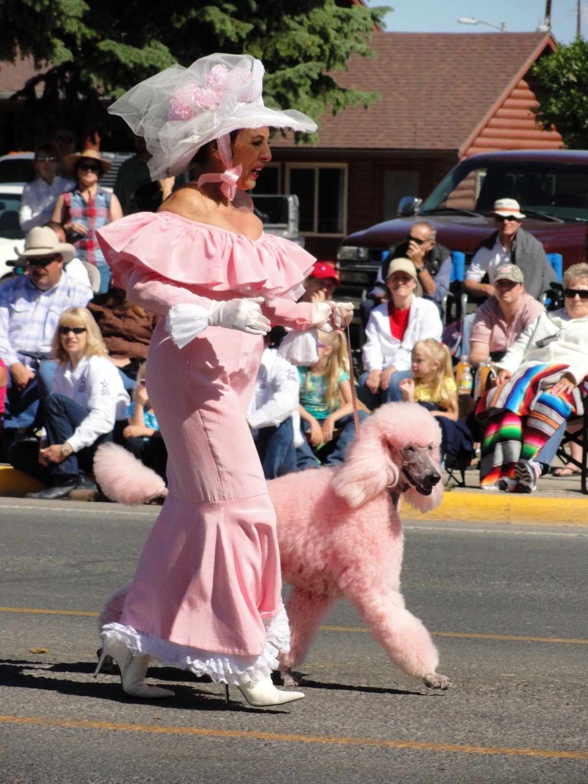 Saturday and Sunday they have the 4th of July parade. They have it on two days so that they can judge the entries and award the prizes on the next day and everyone can see who won. The Wyoming High School Marching band was there. They were great! This band always goes and marches in the Rose Bowl parade. It was a huge parade that lasted one hour and thirty minutes with about 135 units. I liked the one with Buffalo Bill on the stage coach.... John liked the lady in pink walking with the pink poodle! After the parade we went to the Irma Hotel for lunch. There were so many people in town it was very crowded. We went to the bar and could not get close...they were standing out in the street!
We watched the fireworks on the bluff that evening, they were spectacular in the western sky!
As we had stopped in Cody last year on our travels we did not take the trolley tour or go to the Buffalo Bill Cody Museum. Plus the fact that with all the people in town it was very busy! I'm glad that we got to do those things last year.
That is all for now. We travelled to Yellowstone National Park on Monday, July 5th...more on that in the next installment!
Until later, take care,
Candy and Johnny
Sunday, July 4, 2010
Medora, North Dakota
We left Minnesota on June 30 and headed west. After a very rainy June and some hot weather John was ready to get to some cooler and  drier weather. The day was bright and sunny and the roads were good with almost no traffic. It was a long day, 540 miles, but with good weather and good roads, it wasn't a bad drive. We arrived in Medora in time to attend the Pitchfork Steak Fondue. We stopped here last year and put it on our list of things to do again.
The nationally acclaimed Pitchfork Steak Fondue is a traveler's delight. Every evening the chefs load steaks (rib eye or NY strip) onto pitchforks and fondue then western style. You savor your steak as you overlook the picturesque badlands from atop a bluff at the Tjaden Terrace
 . The steak comes with all the fixin's. Plus you are serenaded with western melodies performed live by the cast members of the Medora Musical. This unique dining experience was featured on the national television show, BEST OF, on the Food Network!
The town of Medora was founded in April 1883 by a 24 year old French nobleman, the Marquis de Mores. He named the town for his bride, the former Medore von Hoffman, daughter of a wealthy New York City banker.
The valley of the Little Missouri had been the scene of varied activity long before the arrival of the Marquis. Native Americans had hunted the area for many generations, an example later followed by early white explorers and frontiersmen. General Alfred Sully fought the Sioux in 1864 a few miles southwest of the present site of Medora in what became known as"The Battle of the Badlands." Lieutenant-Colonel George Custer passed through in 1876 on his fatal march west to the Little Bighorn.
The Marquis and Marquise returned to France in the fall of 1886, with the financial failure of the area , with their son and daughter. The Marquis continued his visionary and adventurous lifestyle around the world until being killed by native tribesmen on the Sahara Desert in Africa in June 1896. His widow Medora never remarried, and died in France in 1921.
Another colorful individual drawn to this area was a young New York politician named Theodore Roosevelt. He first arrived to hunt Buffalo in September 1883, immediately fell in love with the land, and invested in cattle raising. He would eventually own two large ranches. In 1901 Roosevelt, at age 42, became the youngest president in the U.S. history, serving until 1909. He called his years in the Badlands "the romance of my life," and often credited his Dakota experiences with enabling him to become president.
When you travel the U.S. in an RV and talk to people many of them will tell you to make sure that you go to Medora for the Pitchfork Fondue. I have to agree with them!!!!
That is all for now.....
Until later, Candy and Johnny
 drier weather. The day was bright and sunny and the roads were good with almost no traffic. It was a long day, 540 miles, but with good weather and good roads, it wasn't a bad drive. We arrived in Medora in time to attend the Pitchfork Steak Fondue. We stopped here last year and put it on our list of things to do again.
The nationally acclaimed Pitchfork Steak Fondue is a traveler's delight. Every evening the chefs load steaks (rib eye or NY strip)
 onto pitchforks and fondue then western style. You savor your steak as you overlook the picturesque badlands from atop a bluff at the Tjaden Terrace
 . The steak comes with all the fixin's. Plus you are serenaded with western melodies performed live by the cast members of the Medora Musical. This unique dining experience was featured on the national television show, BEST OF, on the Food Network!
The town of Medora was founded in April 1883 by a 24 year old French nobleman, the Marquis de Mores. He named the town for his bride, the former Medore von Hoffman, daughter of a wealthy New York City banker.
The valley of the Little Missouri had been the scene of varied activity long before the arrival of the Marquis. Native Americans had hunted the area for many generations, an example later followed by early white explorers and frontiersmen. General Alfred Sully fought the Sioux in 1864 a few miles southwest of the present site of Medora in what became known as"The Battle of the Badlands." Lieutenant-Colonel George Custer passed through in 1876 on his fatal march west to the Little Bighorn.
The Marquis and Marquise returned to France in the fall of 1886, with the financial failure of the area
 , with their son and daughter. The Marquis continued his visionary and adventurous lifestyle around the world until being killed by native tribesmen on the Sahara Desert in Africa in June 1896. His widow Medora never remarried, and died in France in 1921.
Another colorful individual drawn to this area was a young New York politician named Theodore Roosevelt. He first arrived to hunt Buffalo in September 1883, immediately fell in love with the land, and invested in cattle raising. He would eventually own two large ranches. In 1901 Roosevelt, at age 42, became the youngest president in the U.S. history, serving until 1909. He called his years in the Badlands "the romance of my life," and often credited his Dakota experiences with enabling him to become president.
When you travel the U.S. in an RV and talk to people many of them will tell you to make sure that you go to Medora for the Pitchfork Fondue. I have to agree with them!!!!
That is all for now.....
Until later, Candy and Johnny
Grandkids in MN

Part of the reason that we went to Minnesota was to spend some time with our Grandkids. John and Emery (9 mo) got along great, although Grandpot did not change any diapers!!!! He did have a good time discussing the world's problems with the little one.
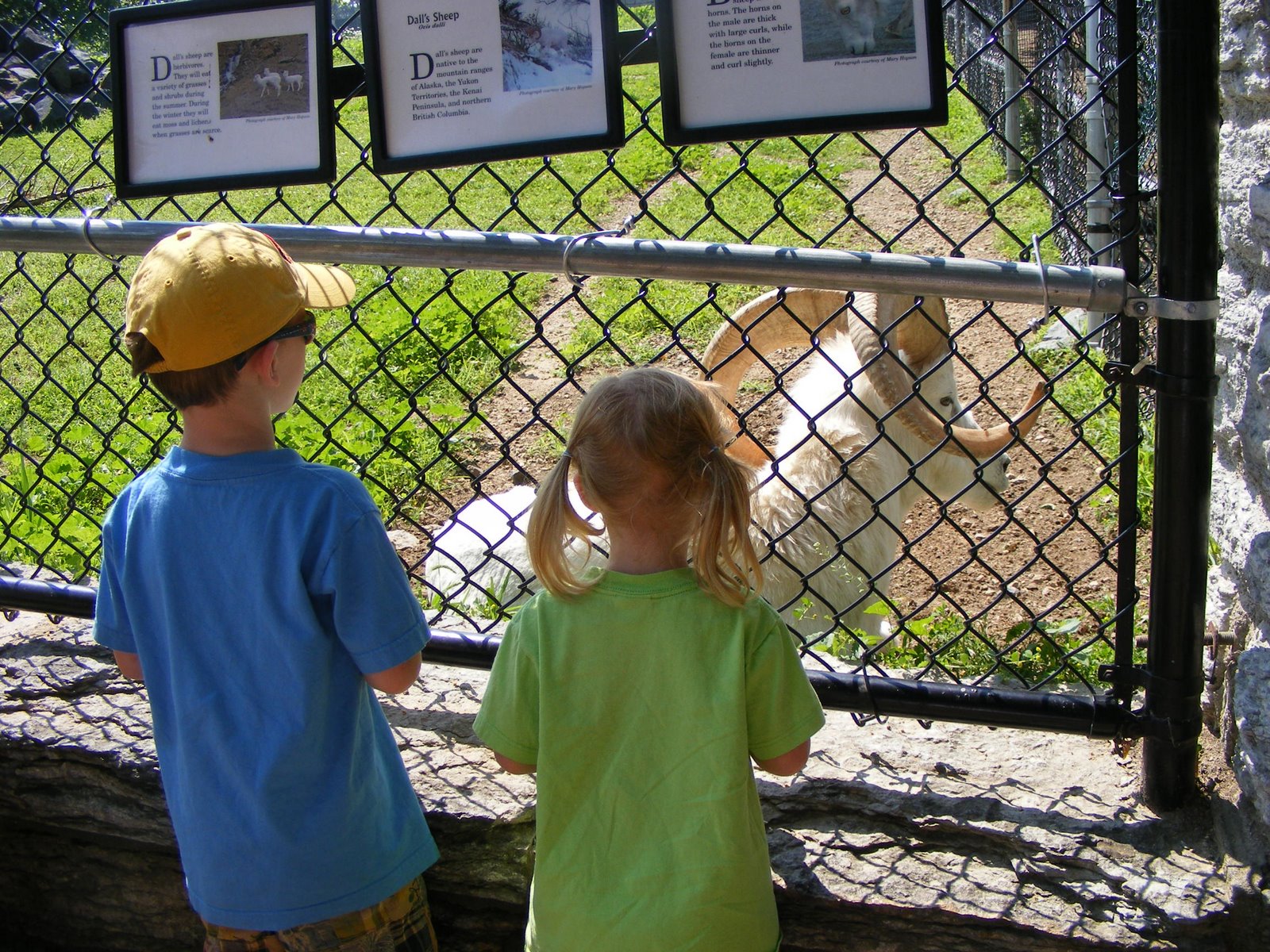
I took Michael (age 5 1/2) and Abby (age 4) to the St. Paul Zoo. We were fortunate to have a nice day!

They had a good time seeing all the animals and then riding on the rides at the zoo. I really think that the best time was eating the popcorn and the cotton candy!

Subscribe to:
Posts (Atom)