Friday, August 31, 2012
2012 August 20, The Badlands National Park, South Dakota
Monday morning we were off to the Badlands National Park, located in southwest South Dakota. The Lakota gave this lands its name, "mako sica," meaning "land bad." Badlands National Park preserves 244,000 acres of sharply eroded buttes, pinnacles, and spires blended with the largest protected mixed grass prairie in the United States. It is desolation at its truest, where you can look for miles and see no sign of civilization. Wind and rain erosion have created an eerie moonscape of deep gorges, sedimentary layers of different colors: purple and yellow (shale), tan and gray (sand and gravel), red and orange (iron oxides) and white (volcanic ash). There are no obstructions in Badlands National Park to mar the horizon. The land unfolds unceasingly until it meets the sky. It is a land close to the sun, replete with some of nature's finest forms!
Erosion continues to this day, frequently revealing long-buried fossils. The Badlands is one of the world's richest Eocene/Oligocene Epoch fossil beds, yielding a wealth of information on the "Golden Age of Mammals" of approximately 25 million to 37 million years ago. Along several trails there are fossilized remains of saber-toothed cats, miniature camels and horses, along with huge rhinoceros-like beasts known as titanotheres, that scientists have discovered in the multicolored layers of the park. Prehistoric bones are still being uncovered today by park officials.
The Badlands was established on January 29, 1930 as a National Monument and on November 10, 1978 as a National Park.
Buffalo Gap National Grassland surrounds The Badlands National Park. Wildlife roams the park's boundaries as well. Bison, pronghorn, mule and whitetail deer, prairie dogs, coyotes, butterflies, turtles, snakes, bluebirds, vultures, eagles and hawks are just some of the wildlife that can often be seen by visitors. In 1994 the near-extinct Black-footed ferrets were reintroduced into the Badlands prairie. These nocturnal animals are rarely seen by the visiting public.
It is such a beautiful place to visit. A must stop for everyone!!!
That is all for today. As you may have noticed, I added a slide show of my photos. I do not think they show the true beauty of the park, but I had so many that I wanted to show more than just a few.
Love to all,
Candy and Johnny
2012 August 18, Wind Cave, South Dakota
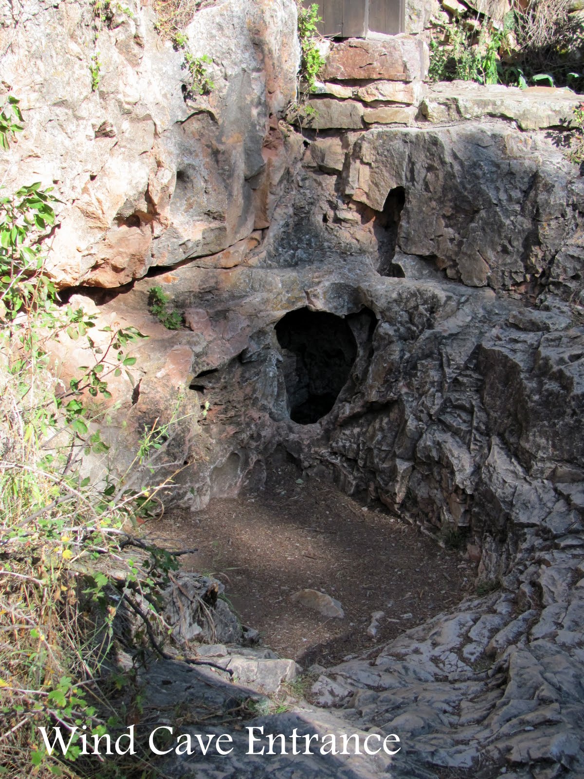


Wind Cave was named for the wind that blows out of or into the natural opening, a small hole in side of the hill. Changing atmospheric pressure outside the cave causes the air outside to adjust.
The Lakota (Sioux), Indigenous People who lived in the Black Hills of South Dakota, spoke of a hole that blew air, a place they consider sacred as the site where The Lakota first emerged from the underworld where they lived before the demiurge creation of the world.
The first documented discovery of the cave by early explorers was in 1881 by brothers Tom and Jesse Bingham. They heard a sound of wind rushing out from a 10-inch by 14-inch hole in the ground. According to the story, when Tom looked down into the hole, the wind was blowing out so hard that it blew his hat off of his head.
The Park offers several cave tours from one to four hours in length. We took the one and a half hour tour with a Park Ranger. The Ranger, showed us the original opening to the cave (see top photo). Luckily we did not have to crawl into that opening!!!!
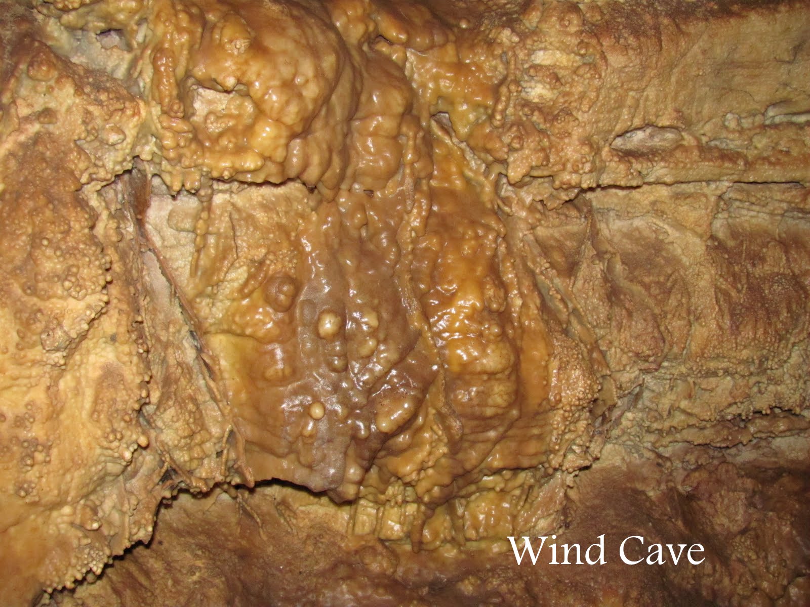
We enjoyed our tour of the cave, the Park Rangers always provide such interesting information!
More later from the Black Hills of South Dakota.
Until then,
Candy and Johnny from the road.
Wednesday, August 29, 2012
2012 August 17 Jewel Cave, Custer, South Dakota
 Friday morning, August 17 and we headed out to see Jewel Cave National Monument, located 13 miles west of Custer, in South Dakota's Black Hills. Jewel Cave is currently the second longest cave in the world, with over 157 miles of mapped passageways (Mammoth Cave in Kentucky, at 390 miles is the longest). Jewel Cave became a national monument in 1908.
Frank and Albert Michaud, two local prospectors, discovered the cave in 1900, when they felt cold air blowing out of a small home in a canyon. It is unknown whether any previous inhabitants of the area were aware of the natural cave opening, which was not large enough for a person to enter.
After enlarging the cave entrance with dynamite, the Michauds

found a cavern lined with calcite crystals, which led them to name it "Jewel Cave". The brothers tried to capitalize on the discovery, widening the opening, building walkways inside, and opening it to tourists. Their venture was unsuccessful, however, news of the cave reached Washington. President Theodore Roosevelt proclaimed Jewel Cave a National Monument on February 7, 1908. The area around the natural entrance to the cave was further developed by the Civilian Conservation Corps in the 1930's. The National Park Service assumed management of the monument in 1933 and began offering tours in 1939.
The Park Service had put a 300 foot elevator shaft to a remote cave area built concrete walks and metal stairs and platforms along a one half-mile loop. The "Scenic Tour" (which we took) was opened in 1972.
Jewel Cave contains the most common types of

calcite formations such as stalactites, stalagmites, flow stone, and frost work, although not in the same abundance as other caves. One of the formations was named "fried egg" and another "bacon". I think you can see why from the photos!
The other day I was one the Jewel Cave web site and noticed that the tours have been suspended for a while as the elevators have been closed due to "technical" problems. Glad that we toured the cave when we did!!!!
That is all for today.
Until later,
Candy and Johnny in the Black Hills


2012 August 16, Buffalo, WY to Custer, SD
 Thursday morning and we were packing up to head East to Custer, South Dakota. The sky was overcast and as we were getting the car hooked up to the RV, the turkeys came out to say goodbye!! At one point there were 16 of them in the area.
As we pulled out onto I-90 East, we were barely out of the Campground in Buffalo and there along the road was a sign for "Wall Drug" in South Dakota.
Wall Drug Store, often simply called "Wall Drug", is a tourist attraction in the town of Wall, South Dakota. It is a shopping mall consisting of a drug store, gift shop, restaurants and various other stores.
The small town drugstore make its first steps towards

fame when it was purchased by Ted Hustead in 1931. Hustead was a Nebraska native who was looking for a small town with a Catholic church in which to establish his business. He bought Wall Drug, located in a 231-person town in what he referred to as "the middle of nowhere", and strove to make a living. Business was very slow until his wife, Dorothy, got the idea to advertise free ice water to parched travelers heading to the newly-opened Mount Rushmore monument 60 miles to the west. From that time on, business was brisk.
Wall Drug earns much of its fame from its self

promotion. Wall Drugs has over 500 miles of billboards on Interstate 90, stretching from Minnesota to Billings, Montana. Wall Drug spends an estimated of $400,000 on billboards every year. Signs have been seen as far away as the metro in Paris, by rail commuters in Kenya and bus passengers in London.
Over a million people stop at Wall Drug every year - 20,000 on a good summer day.
As we continued over to Custer, I was amazed with the number of sheep along the roadside!!
As we were closer to South Dakota and the Black
 Hills, the Black Hills looked more like the "Brown" Hills, the number of trees that were dead on the hill side was amazing. It seems that the mountain pine beetle has once again invaded the Black Hills. The mountain pine beetle is a small insect that lives most of its life in the inner bark of pine trees. They fly from infested tree to new host trees in late June or July. Once they have located a favorable living host pine, the adults tunnel beneath the bark to lay eggs. After the eggs hatch the young, known as larvae, feed within the tree until the following spring when they pupate, a resting stage, for several weeks before becoming adults. The adults emerge from the dead, yet often still green, host and seek a new tree to begin the cycle again.
Mountain pine beetles are native to the Black Hills and have probably inhabited the Hills as long as there has been a pine forest. This insect goes through cycles where they become very abundant and then relatively rare. When the beetle population is very low, only stressed or weakened trees, such as those struck by lightning are colonized. However, about every ten years or so the beetle population increases and the beetles begin colonizing healthy as well as stressed trees. These outbreaks last for about five to 13 years after which the beetle population once again declines.
The first outbreak in the Black Hills occurred in the late 1890's. About five outbreaks have occurred since that time. The outbreak in the early 1970s resulted in the loss of more than 440,000 trees. The last outbreak occurred from 1988 to 1992 and resulted in the death of approximately 50,000 trees. The present infestation is expected to increase during the next five years.
We plan on staying here for about a week to see some of the sights that we have missed in the past. The weather is supposed to be good.
That is all for now.
Love,
Candy and Johnny

Wednesday, August 15, 2012
2012 August 14 Buffalo, Wyoming

Downtown Buffalo you will find the Occidental Hotel. As far back as 1880, in the rip roaring days of early Wyoming The Occidental Hotel was known as the place to stay in northern Wyoming.
The Occidental Hotel was first established in a tent in 1879, just three years after the Battle of the Little Bighorn.
In 1880 the first actual building for the hotel was constructed of logs and the building was formally called the Occidental Hotel (meaning "Western" Hotel.)
For travelers along the Bozeman Trail, the Occidental was an oasis where a weary pilgrim was sure to fine a soft bed and a friendly welcome.

The brick building you see today was constructed between 1901 and 1910. The Hotel had many famous guests including Calamity Jane, "Buffalo Bill" Cody, a young Teddy Roosevelt, Butch Cassidy and the Wild Bunch.
One of its early guests was Owen Wister, he was just a young man traveling out west for his health. He kept his eyes and ears open. Years later, some of the cowboys and gunslingers Wister observed in the Occidental Saloon found their way into the most famous Western novel ever written, "The Virginian."
The year after Wister published the novel, the Occidental started printing a slogan on its letter paper; "Where the Virginian Got His Man." There are some people who are sure the famous shoot-out in "
 The Virginian" - the first "walk-down" in Western literature - occurred in front of the Occidental Hotel.
The hotel has recently under gone $1.6 million historic restoration that began in 1997 and was completed in 2008. The rooms are beautifully decorated with many antiques in evidence.
The saloon looks pretty much as it did in the early days. A great place to sit and have a beer!!
We made a stop at the Big Horn Meat Cutting Co. They have some of the most wonderful smoked pork chops you have ever tasted!
Last night we went to the Winchester Restaurant for dinner. The food there is out of this world, the prime rib and Oysters Rockefeller were outstanding.
From here we head to South Dakota and Custer National Park.
More on that later...
Love to all,
Candy and Johnny


2012 August 7 Meeteetse, Wyoming

Tuesday, August 7 we headed to the heart of the old west, Meeteetse, Wyoming. Meeteetse is a small community 32 miles south of Cody. It was founded in 1896 and takes its name from the Shoshone Indian word meaning "meeting place".
Meeteetse retains a special Western character with watering troughs, hitching posts and historic buildings dating to the turn of the 20th century.
Famed outlaw Butch Cassidy (real name, Robert Leroy Parker) once lived in the area and was a young cowboy in Meeteetse. Its also where he was arrested for the first and only time - outside the Cowboy Bar, which is still in business today.
After his arrest he was convicted of horse thievery.

He was sent to state prison in Laramie where he served 18 months of a two-year sentence. He was released in January 1896. Upon his release he decided that if he was going to be an outlaw, he would be the "most dreaded, most hunted and surely the most illusive outlaw that either North or South America had to contend with". Cassidy eventually left the area and traveled to South America with Henry Longabaugh, alias "The Sundance Kid". He's widely believed to have died in November 1908 after a gunfight with the Bolivian militia.

Another well known almost-resident in the area was aviatrix Amelia Earhart and her husband, George Putnam.
In the summer of 1934, a freckle-faced young woman with curly tousled brown hair sought the solitude provided by the Double D Ranch, located southwest of Meeteetse. Amelia Earhart and her husband spent three weeks at Carl Dunrud's dude ranch. Even though the weather was rainy, Earhart fell in love with the peace and solitude of the mountains and before heading back to New York, she filed a 20-acre mining claim in the area.
She asked Dunrud to do the necessary paper work on the claim and to build them a four room cabin on
 the site. The cabin would be a place she could escape from the public.
Construction on the cabin began in 1936. On May 20, 1937 she began her solo flight around the world at the equator. On July 2, Earhart was lost over the Pacific. By that time her cabin was four logs high and had door frames in place. When Dunrud received word of her disappearance he stopped construction on the cabin and waited for final word of her fate.
The cabin was never finished. We were told there were some remnants of the cabin up in the hills, however a 4-wheel drive vehicle is needed to climb to where the cabin was located. Needless to say, we did
 not get to this site.
One other famous stop in Meeteetse is the Chocolate Shop.
The shop is owned by a local working cowboy, Tim Kellogg. He works as a cowboy during the day and is a chocolatier at night. His chocolates are wonderful!! It is worth a stop!!!
On Wednesday, we went to the Buffalo Bill Historical Center in Cody. This is a museum really worth seeing. There are three buildings. The part housing Wild Bill's Wild West Show artifacts has been redone and I really like what they have done. John loves to head to the gun collection area. They have over 2,700 guns. The art work section is also a wonderful place to visit. They also have some wonderful western sculptures. Another great place to visit.
That is all for now, the weather is supposed to be overcast for the next few days, which does not make for good sight seeing in the mountain, but we shall see.
Love to all,
Candy and Johnny


Monday, August 13, 2012
2012 August 6 Heart Mountain Relocation Center

A moving place and part of our history!
After the bombing of Pearl Harbor on December 7, 1941, many parts of the West Coast were declared military defense zones. The government ordered the removal of all persons of Japanese ancestry and the War Relocation Authority was established in March 1942 to house them in inland camps. The Heart Mountain Relocation Center was one of ten temporary camps constructed to confine over 110,000 men, women and children forced to leave their homes in California, Oregon, Washington and

 part of Arizona. This was the only camp located in Wyoming. Construction on the center began in June 1942 and the first internees began to arrive on August 11, 1942, and by October the population of Heart Mountain surpasses 10,000. The train ride from California took an average of 4 days and 3 nights. For most of the trip shades were drawn, and no one was allowed to look outside.
At the peak of its population the Heart Mountain Center, which covered over 740 acres, contained nearly 11,000 people housed in 450 barracks. Although surrounded by barbed wire and armed guards, the internees kept the camp functioning as a small city. At the time it was the third largest city in Wyoming.
Between 1942-1945 185 persons died at Heart Mountain. Some bodies were sent to Great Falls, Montana for cremation at a cost of $100; others were buried in the camp cemetery. All but five of the bodies were exhumed and removed to the West Coast after the war. The five unclaimed bodies were moved to the Powell Cemetery. (The town of Powell, Wyo. is located 11 miles to the north of were the camp was situated.)
The Heart Mountain Relocation Center officially closed on November 10, 1945, and the last train of internees left on November 15. The internees received a train ticket and $25 to begin their new lives away from the camp. When these people were released, many internees found they had nothing to return to as their homes and businesses had been foreclosed on because of their inability to continue payments while detained in the camp.
The national security measure, established for the supposed "protection" of Japanese-Americans (and they were American Citizens), has since been criticized as an overreaction. The Congressional Commission on Wartime Relocation and Internment of Civilians determined the incarceration was not justified by military necessity, as the government had claimed, but was the result of racial prejudice, war hysteria and a failure of political leadership.
Several relic buildings and the hospital chimney spire rising in the sky remain as visible reminders of Heart Mountain Relocation Center. In 1996 the Heart Mountain Wyoming Foundation was founded. During the last decade the foundation has achieved a number of significant milestones in its mission to preserve the Hear Mountain site. In 2001 they were able to purchase the land, once part of the original camp, to build an interpretive center, which finally opened on August 20, 2011. In 2003 it restored the military honor roll of more than 800 names of people who served in the military from the camp, and in 2005 a self-guided 1,000 foot walking trail with eight stations was dedicated.
A moving place!
That is all for today,
Candy and Johnny
Friday, August 10, 2012
2012 August 5, Cody Balloon Fest
 Sunday morning we got up at 5am to head over to Mentock Park in east Cody to watch the launch of the 17th annual Wild West Balloon Fest.
There were about 25 or so balloons from around the U.S. The balloons were finally launched about 6:20am and it was a beautiful sight!!! The photo's here do not do the balloons real justice.
After the balloons were on their way we headed to the Irma Hotel for a wonderful breakfast. (The Irma
Hotel was built by Bill Cody and he named it after his
 youngest daughter).
Love to all,
Candy and Johnny


Subscribe to:
Posts (Atom)