Monday, July 22, 2013

2013 July: June Lake Loop, California

 South of Mono Lake, just off Hwy. 395 is the June Lake Loop.

The road winds past the community of June Lake, which sits on the shores of its namesake.  Gull Lake is next, followed by Silver Lake and Grant Lake.

June Lake's looped valley, often described as a horseshoe-shaped canyon, was formed by glacial action.  The Rush Creek glacier split in two when it encountered the resistant rock of what is now known as Reverse Peak.  The main glacier flowed toward the north creating the Rush Creek Canyon.  Another glacial branch turned south and east but its flow was impeded and eventually stopped as the granitic bedrock on this southern branch created an uphill path toward the volcanic area of the Mono Craters.  When the glacier receded it left behind terminal moraine material in the area now known as Oh! Ridge.


The Loop's four glistening lakes are renowned for fishing, and are stocked with trophy-size Alpers trout.

It was a pretty drive!

More on Yosemite later...
Until then,  Candy and Johnny


Posted by Picasa

Saturday, July 20, 2013

2013 July 13 California; Mono Lake


 Saturday, July 13 and packed up again ans headed for California.  We headed to Coleville, California and parked at the Meadowcliff Resort.

After we set up camp we were off exploring.  We headed down Highway 395 and came upon Mono Lake, one of the oldest continuously existing lakes on the continent.  Fed by huge glaciers during the last Ice Age, Mono Lake was 60 times larger than the 66 square miles it covers today.

Mono Lake is naturally salty and alkaline because it has no outlet.  The only way water leaves is via evaporation.  The Sierra streams that flow into Mono contain only trace amounts of minerals and salts but those minerals and salts stay and their concentrations grow over the years.

The lake's most distinctive feature is it's eerie tufa (pronounced "toofah") towers visible along much of the shoreline - mineral structures  created when fresh-water springs bubble up through the lake's alkaline water.  Some of these  tufa towers are up to 30 feet high.

Mono lake may seem lifeless, however, Mono supports a simple but amazingly productive food chain.  It begins with algae that serves as food for two other species - bring shrimp and brine flies which, in turn, serve as the major food source for literally millions of water birds.  It's estimated that some 85% of California's seagulls started their life here at Mono Lake.

The City of Los Angeles, hundreds of miles to the south, has been diverting water from the Mono Basin since 1941.  That diversion had cut the lake volume in half and has doubled its alkalinity and salinity.  An extended court fight has finally stopped the water diversion and Mono Lake is once again growing - albeit slowly.

Who knew????

More later, but this was very interesting!

Until later, Candy and Johnny on the road.....


Posted by Picasa

2013 July Lake Tahoe, Nevada


We arrived in Carson City, the capital of Nevada on Wednesday, July 10.  Carson City is located east of Lake Tahoe and south of Reno.  It was settled in 1858 and named for Kit Carson.  The discovery of silver in 1859 in the nearby town of Virginia City helped to stimulate Carson City's economy.  The federal government established a mint at Carson City, which later became the Nevada State Museum.  It became the capital of Nevada in 1864 when Nevada gained statehood.

Thursday dawned a beautiful day in the mountains of Nevada so we headed over the hills to Lake Tahoe.  Lake Tahoe sits on the California-Nevada border and covers 193 sq. miles.  The lake sits at an elevation of 6,229 feet.  It is 22 miles long and 10 miles wide.  The lake is 1,645 feet deep - the third deepest in North America (the deepest is Crater Lake in Oregon, being 300 feet deeper).  Additionally, Lake Tahoe is listed as the 26th largest lake by volume in the world at 122,160,280 acre-ft.  Approximately two-thirds of the shoreline is in California.

Most people are mesmerized by the cold, clear, waters of this grand mountain lake.

Lake Tahoe is fed by 63 tributaries, which drain an area about the same size as the lake; half the water entering the lake is rain falling directly on it.

 The Truckee River is the lake's only outlet which flows past Reno and into Pyramid Lake.  From there, it just evaporates as there is no outflow to the Pacific Ocean.

The lake never freezes as it is so deep and big.  The water is constantly moving.  As surface water approaches freezing temperatures, it sinks.  Warmer, lighter water then rises to the top, mixing with the colder sinking water.  The lake stays a constant 39* near the bottom and warms up to 68* along the shoreline in the summer.

The color of the lake is a brilliant blue.  The lake takes much of its color from the sky, reflecting it like a big, deep mirror.  During storms, the lake looks gray or nearly black.

In some places, the water is so clear that objects can be seen on the bottom in 75 feet of water.  Much of the rainwater coming into the lake flows through marshes or meadows which filter out impurities.  The lake will probably not stay this clear as Lake Tahoe is naturally filling with sediments.  These come from existing roadways,
new construction and vehicle exhaust, all stimulating algae grown.

What a wonderful way to spend a day along such a beautiful shoreline!

From here we are heading to Yosemite National Park.  More later.

Love to all,

Candy and Johnny


Posted by Picasa

Monday, July 15, 2013

2013 July 9, Provo, Utah to Winnemucca, NV


 Tuesday, July 9 and we were off to Winnemucca, NV. 
We had planned on taking Highway 50 across to Carson City.
Highway 50 was labeled the "loneliest road in America" by Life Magazine in 1986.  They said there were no point of interest or interesting stops along the way.  This however is not the case.  It is one of the states most scenic and historic corridors.  Highway 50 traces the route of the Pony Express and Overland Stagecoach trails.

John, however, decided to take I-80 out of Salt Lake City due to weather in the area.
I-80 skirts along the Great Salt Lake toward the Nevada border.

The Great Salt Lake is both the largest body of
water between the Great Lakes and the Pacific Ocean and the largest salt lake in the western hemisphere.  The Great Salt Lake is the major remnant of Lake Bonneville, a freshwater lake of the Pleistocene era (75,000-7,250 B.C.) that occupies much of western Utah.  No streams empty from the lake, and its high salinity is caused by the accumulation of minerals with no removal and the accompanying water evaporation.


 Antelope Island, with an area of 42 square miles is the largest island of 10 islands located with the Great Salt Lake.  The island lies in the southeastern portion of the lake, near Salt Lake City and becomes a peninsula when the lake is at extremely low levels.
The first known non-natives to visit the island were John C. Freemont and Kit Carson during exploration of the Great Salt Lake in 1845.  It is said they shot a pronghorn antelope on the island and in gratitude for the meat they named it Antelope Island.

As we continue along I-80 we come to the Bonneville Salt Flats, desert area in Tooele county, in northwestern Utah.  It is 14 miles long and 7 miles wide.  The smooth salt surface of the Flats is ideal for auto racing, and several world land speed records have been set here.  The Flats are part of the Great Salt Lake Desert, NW Utah, the former bed of Lake Bonneville, whose area once covered 19,500 square miles.  The area was named for U.S. explorer Benjamin de Bonneville.

Entertainment filmed at the salt flats include: Independence Day and Pirates of the Caribbean: At World's End.

Due to extraction of salt from the area, the salt flats have begun to disappear.  Once around 90,000
acres in size, they are now only 30,000 acres.  The
salt layer is thought to be shrinking due to the use of the salt in making of potash, a mineral ingredient used in fertilizer.
It has been estimated that over 55 million short tons of salt have been taken from the salt flats since mining began in 1963.  Geologists estimate that 18 inches of salt crust have been removed from the flats, and that the reduction of salt happens at a pace of one percent per year.  In some areas, the salt is now a mere 1/2 inch thick.
 As we continue our drive across Utah into Nevada we began to think about all the pioneers that crossed this area in covered wagons.  There were signs along the road about the Carson Trail and California Trails that we were following.  These folks really had a sense of adventure!!

For weeks these emigrants crossed vast grassland which was hot by day and cold at night.  Often violent thunderstorms swept down on the hapless travelers. From the Great Salt Lake to the eastern escarpment of the Sierra Nevada, emigrants traversed the Great Basin.  Most had seen nothing like this, for nothing like this exists east of the Rocky Mountains.  They had to cross the Mile Desert to reach the next reliable water in either the Carson River or the Truckee River.  Survivors were then faced with the final obstacle before reaching California, the towering Sierra Nevada mountains.  It is a trip that I am not sure that I would have liked to make in a wagon!!!

There were over 250,000 pioneer emigrants on their trip across the frontier to the promised lands of California and Oregon in the 1840's and 1850's.  This was the largest mass migration in the history of America!

That is all for this installment.

Love to all and hope that you are having a wonderful summer.  More from the road later.

Candy and Johnny


Posted by Picasa

Friday, July 12, 2013

2013 July 6, Durango to Provo, Utah

 Saturday, July 6 and we left Durango and headed to Utah.  We are going to stop in Provo for a couple of days.
July 4th we had a wonderful picnic with Chris and Jan.  What could be better than Brats, Potato Salad, Watermelon and Blueberry Pie?
The smoke had returned to Durango for July 4th and 5th, so we were glad to leave and head West.  I still have some of my cold and allergies and the smoke was not good for my breathing.

We headed West and passed Mesa Verde and then

 headed toward Moab.  The weather cooperated and we did not have to drive through any rain.  We stayed in Provo, Utah, 43 miles south of Salt Lake City, and the 3rd largest city in Utah.   We had a couple of days to rest and do some shopping.  We found the local Costco.  At home if you go to Costco on Sunday, the place it packed!!  In Provo, the store was empty, you could actually get near the meat counter, what a surprise!!!


 While we were in Prove we did have several strong thunder storms come through.  The park we stayed at was right along the Provo River, and Lake Utah.  Lake Utah is the largest freshwater lake in Utah.  Lake Utah State Park was just down the road from the RV Park.  When the rain storms hit the boats made a mass exit!!!

From here we are heading to Nevada for a couple of days.

More on that later.

Hope all is well with everyone, remember that we love to hear from you also...

Candy and Johnny
Posted by Picasa

Wednesday, June 26, 2013

2013 June Baker's Bridge, CO

 Finally, after being sick for about 2 weeks, I am on the mend and able to get out for short drives.  On Tuesday, June 25th, we had to take to coach to the Durango Glass Company as we had a cracked windshield.

As it was a beautiful day, we headed out to find  Baker's Bridge, which is about 13 miles north of Durango.  My friend Shirley had told me about the Bridge, and I thank her for it was truly a lovely place.

It seems that in 1969, the movie 'Butch Cassidy and the Sundance Kid' was made, which stared the dynamic duo of Robert Redford and Paul Newman.
It was a 20th century Fox film.  The film was about

 the famous outlaw pair and won four Academy Awards, including the best song 'Raindrops Keep Fallin' on My Head'.
In the movie there is the famous jump scene.  It was filmed here at Baker's Bridge.  The scene looks different from this area as the water was blocked to create the appearance of a more rapid-like river and the jump itself was made to look farther through Camera magic to create the illusion of a much longer fall to the water.

The bridge was named after Captain Charles H. Baker, who discovered Gold in the San Juan's in 1860, he was later killed by Indians.

I am so glad my friend told me go and visit this place.  The Animas River was beautiful here.

Hopefully we will now be able to see more places here before we leave and head West.

Until later,  love to all,

Candy and Johnny


Posted by Picasa

June 2013 Cinnamon Pass, Colorado


 Five days after our arrival in Durango, Co.  I came down with a awful summer cold!!!  Here I am in this beautiful place and I am so sick that I do not feel up to doing anything. 

Another couple of airline friends had also come to Durango, however they were only staying here for a week before heading West.  It was fun to see Gary and Cortney.  As per the custom, we had dinner waiting for them the day that they arrived.

It was the following day that I came down with mt cold, so at least we had one good dinner together.

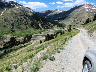
One day, the three guys decided to take Chris's 4 wheel jeep to Cinnamon Pass.  This is one of Colorado's most scenic drives.  You can drive the loop in any SUV with good clearance, though you may find challenges in some spots.

The trail follows the Gunnison River for some amazing views.  Along the trail you climb switchbacks and steep sections to the top, sometimes the switchbacks are a bit rocky.  I understand that tire placement here is a must!
If you are careful you find yourself at Cinnamon Pass,

 between Cinnamon Mountain and Wood Mountain, a crest marked with a sign, at 12,640 feet.  From there the trail takes you down into the town of Silverton.

Along the way John found a "friend".No, he did not keep him for a pet!!!!

As I was not able to make the trip and the guys seemed to want a "boys" outing, I gave my camera to John, and I think he took some pretty good photos.

Stay tuned for later updates...

Candy and Johnny


Posted by Picasa