Saturday, September 24, 2011

September 5, 2011 Bow Valley Parkway

When we left Moraine Lake, instead of turning on to
TransCanada #1 we decided to take the Bow Valley Parkway, which parallels the TransCanada.  It is a very scenic and more leisurely experience. 
Along the way we passes Castle Mountain, which rises to a height of 9073 feet above sea level.
The name '. Castle Mountain' dates to 1858 and is the title used today.  However, between 1946 and 1979, it had a different appellation: Eisenhower Mountain.  The change came on orders from Prime Minister William Lyon Mackenzie King who wanted to honour Dwight D. Eisenhower, the supreme commander on the western from in World War II.  However, this caused considerable resentment because it replaced a long-standing and popular title and because people felt uncomfortable naming a mountain after a living person.  Today Eisenhower's name is associated only with the separate 9027-foot tower at the east side of the main massif.

Along the route back to Banff along the road we encountered this Ram along the road and then as we turned to return to TransCanada 1 the mule deer were taking their place in the road.

 More wonderful sights to come.

Candy and Johnny
Castle MountainPosted by Picasa

Sept. 5, 2011 Moraine Lake


Monday, September 5, 2011 and yet another beautiful day here in Canada.  As in the United States it is a holiday here, Labour Day.  We decided to head to Lake Louise and Moraine Lake.  We began our day early and reached Lake Louise however decided to begin our day at  Moraine Lake.  A good decision it turned out!!!   Moraine Lake is less than 9 miles from Lake Louise and located in the Valley of Wenkchemna Mountains.  Many visitors feel that Lake Moraine is more exquisite and spectacular than its larger and more famous cousin.
Moraine Lake is also quite famous in that an image of the Valley of the Ten Peaks, surrounding the lake, appeared on the back of older versions of the Canadian $20 bill.  The highest peak is Deltaform, at 11,230 feet, and all of the peaks, Fay, Little, Bowlen, Perren, Septa, Allen, Tuzo, Deltaform, Neptuak and Wenkchemna, are white capped with what remains of the Wenkcjemna Glacier.  The huge mountain to the north, with the glacier on its summit, is Mt. Temple, at 11,636 feet, the third highest mountain in Banff National Park.

It is said that the lake is misnamed!  The person who christened it in 1899, Walter Wilcox, thought it, like Lake Louise, had its origins because of a terminal glacial moraine. (A moraine is a kind of dam created by the debris left behind by a glacier which blocks up a valley so that a lake can form behind it.)  However, this lake formed after a rock fall from its neighbour, the "Tower of Babel", dammed the run-off from the surrounding mountains to create Moraine Lake.

The hike around this lake was a wonderful walk also.

We had wanted to return to Lake Louise, however 

when we left the Moraine Lake area the traffic was awful and backed up for a mile or more so we decided to return to Lake Louise after the holiday.  With the holiday and the nice weather is seemed that everyone was out for the day!!!

More later,

Candy and Johnny


Posted by Picasa

Sept. 4, 2011 Yoho National Park, Canada


Sunday, September 4 dawned another beautiful day in Canada.  We decided to head out to Yoho National Park.  Yoho is located in British Columbia, between Glacier and Banff national parks.
Yoho National Park boasts towering rock wall, spectacular waterfalls, and 28 peaks over 9840 feet in height - it's no wonder that the word "yoho" is a Cree expression of awe and amazement.  Yoho National Park was created in 1886 and encompasses 505.6 square miles of the Rocky Mountains Western slopes.

Our first stop was at the view area for the Spiral Tunnels for the Canadian Pacific Railway.  In 1884, the Canadian Pacific Railway could spare neither time or money to care a gradual descent down the west side of the kicking Horse Pass.  Instead, the CPR obtained the federal government's permission for a steep but temporary line.  The proposed Big Hill track dropped at a dizzying 4.5% grade - twice the maximum allowed in their government contract.
Going down, it took a combination of spur lines, safety switches and signals to keep the trains under control; going up, it took extra engines to push them over the pass.  The line was costly to operate - and dangerous!  There had to be a better way.....
Work on the tunnels began in September 1907, and was completed 20 months later.  One thousand men were involved in the construction, working for $2.25 per day.  In each tunnel, crews advanced in from both ends..and eventually met within five centimeters of perfect precision.  The Spiral Tunnels line doubled the length of the original Big Hill but cut the grade in half.  A very impressive engineering accomplishment!

Our next stop was at TaKakkaw Falls.  Takakkaw means "magnificent" in Cree, and when you stand at the base of these falls you can see why.  This  833 foot high waterfall is one of the highest in Canada.
Daly Glacier, 1150 feet from the brink of Takakkaw Falls feed the falls, the glacier in turn is fed by the Waputik Ice field.  Snow falling on the ice field becomes moving ice in the glacier, which melts to become Takakkaw Falls.
Looking at these falls, it is easy to understand how Yoho came by its
 motto - "rockwalls and waterfalls".

From Takakkaw Falls we continued onto Emerald Lake.  Yoho's 61 lakes and ponds.  We walked the 3.22 miles around the lake.  What a beautiful way to spend an afternoon!!  Emerald lake is fed by glaciers and is dammed by a glacial moraine.  The lake occupies a basin surrounded by high mountains.  This arrangement results in frequent rain in the summer and heavy snows in winter. 

The next stop on our visit to Yoho National Park was at the Natural Bridge.  In this part of the valley, Kicking Horse River is eroding a shallow canyon through weak shales of the Chancellor Formation.  However, at Natural Bridge it encounters a tightly folded outcrop that offers more resistance to the flowing water.  The river has succeeded in eroding a channel through the rock to undercut it, just upstream from its edge to undercut the crooked bridge.
In terms of geological time, the Natural Bridge will be a temporary feature.  Eventually, the river will completely undermine it, and the bridge will collapse.  Then a new waterfall may form upstream.
Downstream, you can see rock formations in the riverbed that suggest
where this process took place in the past.

Friday, September 23, 2011

Banff, Alberta, Canada


On Saturday, September 3 at about noon we arrived at Banff, Alberta, Canada. The scenery along the way was fantastic. Everywhere you look are beautiful mountains with glaciers. The town of Banff is located in the southern part of Banff National Park.

Banff was Canada's first national park, and the third on the planet (after Royal in Australia and Yellowstone in the US). The park originated not from a lofty idea, but from a dispute over the hot springs at what is now known as the Cave and Basin. With its own agenda to capitalize on the scenery adjacent to the new railway (Canadian Pacific Railway), and a huge financial deficit to recover, the Canadian government stepped in and, on November 28, 1885 set aside the springs and a surrounding area of 26 square km (10 square miles) as a federal reserve - the forerunner of Banff National Park.

In 1886, George Stewart recommended that additional area be added.  His comments were quickly heeded, and in June 1887, the Canadian government established Rocky Mountain Park. Upon the enactment of the National Parks Act in 1930, the park was renamed Banff.


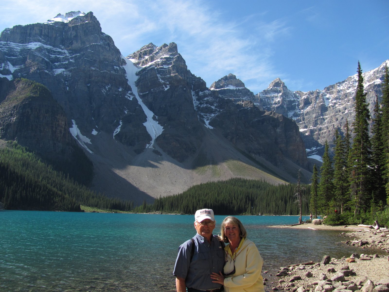
As it was a holiday weekend in Canada, the town was full and very busy.  After we set up camp at Tunnell Mountain campground, we headed downtown to the information center.  The people that we spoke to there were most helpful!  As it was a holiday, we were told that the best thing to do the rest of the day was to see the sighs around town and then head out very early the next day to see other sights.

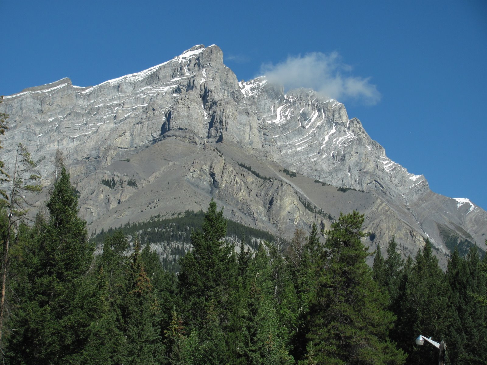
On our way into town we had seen Mount Rundle (photo after town photo). Mt. Rundle, named for Robert Rundle, the missionary who passed through the region in the 1840's, rises ti 2,949 meters (9,700 feet).  It is one of Banff's signature sights and is often seen on postcards or paintings with the Banff town site nestled just below it.

We came out of the information center and turned left and headed toward the Bow River that flows through town.  The walk along the riverbank to Bow Falls offers escape from the busy streets nearby, and features fine views of the river.
The Bow River is the longest river in Banff National Park.  From its headwaters at Bow Lake, 90 km (55 mi)

to the north, it drains an area of 2210 sq. km (853 sq. mi.).  After flowing through Banff and out of the mountains, the Bow eventually combines with the Oldman River in southern Alberta to form the South Saskatchewan River.  The Bow River's name probably comes from the Cree words "manachaban sipi" - "the place from which bows are taken."  First Peoples made hunting bows from Douglas-fir saplings found on its banks.
Slightly downstream from the falls, the Spray River enters the Bow River at the site of the Banff Springs Hotel ( on the bank above).

People originally came to Banff for the healing waters of the hot springs located here.  Dr. R.G. Brett set up a sanitarium.  He knew a good thing when he saw one.  For the privilege of using the water, Brett paid the government $15.00 per tub, per year.  For the benefit of taking a dip, clients paid substantially more - $2.00 a day.  The federal government took over Brett's lease in 1932 and built the forerunner of the hot springs facility that is in Banff today.

We walked back into town and found the Olde Irish Pub and stopped in for a pint.  What a glorious day.

More later, we have seen and done so much it is difficult to
keep up.

More later,  Candy and Johnny


Posted by Picasa

Wednesday, September 14, 2011

Golden, British Columbia, Canada


September 3 dawned with a glorious blue sky and fog rising off the Columbia River below the campground. Looks like the weather will be with us as we head off to Banff.

Here is some of the history that we learned along the way about Golden.
It was back in 1807 when David Thompson first crossed over the Rocky Mountains here in Canada and traveled along the Baeberry River to the future site of Golden. In search of the Columbia River and, ultimately, a passage to the Pacific Ocean, it was Thompson's sense of exploration that led him here.
Golden would simply not exist without Canadian Pacific Railway (CPR). In fact, the railway's presence helped establish Golden's place in Canada. As the CPR constructed its cross-country network of rails, it used Golden as a base camp as it extended further into the western part of B.C.  The railway was completed in 1885 and Golden soon became a prominent stop on the line.
The CPR also paved the way for the Trans-Canadian
Highway.  The Trans-Canada Highway was opened in 1962 through Rogers Pass and offered access to the heart of Canada's National Parks.

We continued east on the Trans-Canada #1 Highway and it was not long before we entered Yoho National Park and some of the most beautiful scenery.  From the icy blue glacial waters in Kicking Horse River to the snow covered mountains.

We did not stop along the way, however we made plans to return for more exploration after our arrival in Banff to set up our camp for the next seven days.  With scenery
this beautiful I can hardly wait!!!!

Until later,
Candy


Posted by Picasa

Tuesday, September 13, 2011

Kamloops to Golden, B.C., Canada


Friday, September 2 and we once again headed to the east.  We left Kamloops on Canada #1.  We came to the town of Sicamous. Along the river banks there were a great number of houseboats.  As we continued toward the east there was a sign that stated that Sicamous was the "houseboat capital of Canada".  I never thought about Canada and houseboats!  You just never know what you will find out along the road.

As we continued east we entered Canadian Glacier National Park.  We stopped at the visitor center in the park and obtained our Canadian National Park Pass (which is needed to stop in any of the Canadian National Parks).  The park rangers were very helpful and full of information. Once again there were clouds over the mountains and fresh snow on the tops.  What a beautiful sight!  As we left the ranger station we passed over Rogers Pass at 1327 meters or 4352 feet.  We also passed from Pacific time to Mountain time.

We finally reached the town of Golden and stayed at the Whispering Spruce Campground.  What a nice park, lots of trees and at the edge of a cliff overlooking the Columbia river.

The Columbia river begins its 1243 mile journey in the southern Rocky Mountain Trench in British Columbia, Columbia Lake - 2690 feet (820m) above sea level - and the adjoining Columbia Wetlands form the rivers headwaters.  The Columbia River is the largest river in the Pacific Northwest region of North America.  By volume, the Columbia is the fourth largest river in the U.S. and it has the greatest flow of any North American river draining into the Pacific Ocean.
The Columbia River rises in the Rocky Mountains of British Columbia, Canada and flows northwest and then south into the state of Washington, then turns west to form most of the border between Washington and the state of Oregon before emptying into the Pacific.

Tomorrow we will reach Banff and begin our tour of the Canadian

National Parks. We have been looking forward to this trip for a while.  I just hope that we will have good weather!!  We had planned to head to Canada in July but with the Calgary Stampede we could not find camping space.  As it turned out the month of July was very rainy.

More later,

Candy
 
Posted by Picasa

On to Canada


It was a bright and sunny morning on September 1 when we said our farewell to Anacortes and headed north to Canada. As our departure was early we had said our goodbyes to our friends the evening prior. We had a wonderful month here in the Northwest. Good weather, good friends, good food and good times. We headed north on I-5 toward Bellingham and then took highway 20 to the boarder crossing at Sumas, Washington. The crossing was very smooth... no waiting. The only thing that Canadian Customs wanted to know was if we had any weapons with us, which we do not carry.

As we headed north on Canada #1 to our first stop at Kamloops, British Columbia, Canada the skies began to darken and there was rain on the windshield. We climbed higher and higher and we crossed Coquihalla Pass at 4081 feet.  It looked like there was some fresh snow on the mountain tops.
We reached our camping spot for the nigh at the  Kamloops RV Park and parked in spot #3.  It was a very nice park.

Tomorrow on to Golden, BC, Canada before heading to Banff.

Candy


.


Posted by Picasa