Thursday, August 9, 2012

2012 August 3, Through Yellowstone to Cody, Wy.


Friday, August 3 and we are on our way to Cody, Wyoming.  Our route takes us once again through Yellowstone National Park.

Yellowstone park is located at the headwaters of the Yellowstone River, from which it takes its historical name.  Near the end of the 18th Century, French trappers named the river " Roche Juane" which is probably a translation of the Minnetaree name (Rock Yellow River).  Later American trappers renamed the French name in English as "Yellow Stone"  Although it is commonly believed that the river was named for the yellow rocks seen in the Grand Canyon of the Yellowstone, the Native American name source is not clear.

Yellowstone National Park spans an area of 3,468.4 square miles, comprising lakes, canyons, rivers, and mountain ranges.  Yellowstone Lake is one of the largest high altitude lakes in North America and is centered over the Yellowstone Caldera, the largest supervolcanos on the continent.  Half of the world's geothermal features are in Yellowstone.

As you can see from the photo's we once again ran
 into a traffic jam in Yellowstone!  The huge herd of Buffalo were in the road and all over the hillside.

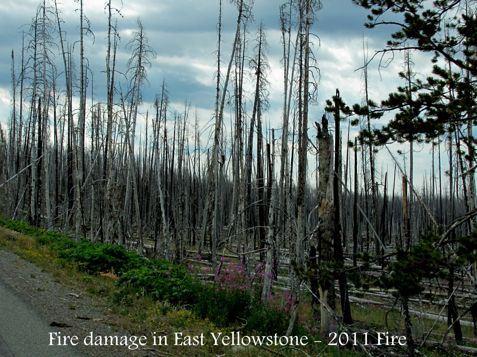
As we passed Yellowstone Lake, I noticed that there had recently been a fire in the area.  The fire occurred on the east side of Yellowstone in the fall of 2011.  Although the fire destroyed many of the trees is still made for a beautiful sight.

We will be in Cody, WY for about a week.  More later on the sights from Cody.

Love,  Candy and Johnny


Posted by Picasa

2012 August 2 Yellowstone National Park


Thursday, August 2, we headed to Yellowstone National Park to see some of the places we had missed in the past.

Our first stop was Gibbon Falls.  The last time we were here the road was being repaired and we could not stop here.  Gibbon Falls, located on the Gibbon River is a fantail fan falls, with a height of 84 feet.  The original name of the falls on the early maps was "First Canon Falls."

Our second stop was at Artists' Paintpots.  This is
a smaller but lovely thermal area.  A mile walk trail takes visitors to colorful hot springs, 2 large mud pots and a section of forest burned in 1988.  The water in the pools is 171* F and boils at about 197* F at this altitude.  The water is slightly acidic, with a pH similar to vinegar.

Next stop was at Roaring Mountain.  Geologists Arnold Hague and Walter Weed named this thermal feature in 1885.  Hague stated " it takes its name from the shrill, penetrating sound of the steam constantly escaping from one or more vents located near the summit, and on a calm day, or with favorable wind, the rushing of the steam through the narrow orifices can be distinctly heard".  It is a barren, furrowed, white
ridge, rising 400 feet from the base.  The leaching of sulfuric acid has produced the stark, barren environment.

Our next stop was an animal traffic stop due to a sighting of Moose grazing in a nearby field.  I did manage to get a few photo's from a distance, but as usual, there were the crazy folks who ran down into the field to get a closer shot!!!!

We next happened upon Rustic Falls.  This falls is a plunge/horsetail/fan with a height of 47 feet.  It is a natural falls but rumors persist that it is man-made.  These stories probably originated because Glen Creek's flow has been artificially augmented by means of an underground pipe from Indian Creek.  Regardless, it is s beautiful waterfall in the park.

Another place that we had never stopped at is Mammoth Hot Springs.  Elevation 6,735 feet.  Mammoth Hot Springs is a large complex of hot springs on a hill of travertine in Yellowstone National
Park adjacent to Fort Yellowstone.  It was created over thousands of years as hot water from the spring cooled and deposited calcium carbonate (over two tons flow into Mammoth each day in a solution).  Although these springs lie outside the caldera boundary, their energy has been attributed to the same magmatic system that fuels other Yellowstone geothermal areas.
Algae living in the warm pools have tinted the travertine shades of brown, orange, red, and green.

As we continued around the Grand Loop Road, there were elk feeding in the area.  They do not seem to care if cars go by, they just continue to graze!


Our next waterfall along the road is Undine (pronounced un deen).  This is a multi-step falls that consists of three plunges and
is visible from a roadside overlook.  Its height is 60 feet.
Undine Falls appeared on the cover of National Geographic magazine in July 1977.  Undine was named for wise, usually female water spirits from German mythology who lived around waterfalls and who could gain souls by marrying mortal men.  Named in 1885 by geologist Arnold Hague.

A little further along the road is Wraith Falls.  It is a short 0.5 mile walk from the parking area.  Like an apparition, Wraith falls appears suddenly on the cliff as a white bulb on Lysine Creek.  It tumbles over 90 feet, but can dry up in the late summer.  The falls is really more of a cascade due to the low slope angle, but appears like a legitimate waterfall when viewed straight on.

Once again, Yellowstone National Park did not fail to impress!!!  There is so much to see, we have been here four times and I still do not thing we have seen it all and do justice to the park!!!

Tomorrow we are off to Cody Wyoming, and have to pass through the park once again... we shall see what finds are on the  way tomorrow.

Love to all,

Candy and Johnny


Posted by Picasa

Wednesday, August 8, 2012

2012 August 1 Cliff and Wade Lakes, Idaho


Wednesday, August 1, we went in search of Cliff and Wade Lakes in Idaho.  They are located about 26 miles from the Red Rock RV Park, hidden in the hills nearby.

Cliff and Wade Lakes sit on a geologic fault that form a chasm that filled with water; cliffs surround much of the lakes shorelines.  Cliff lake is the larger and somewhat more isolated of the two.  Wade lake is more accessible, it is spring fed and stays partly ice-free in the winter.

These lakes are part of the Hidden Lake Chain of
lakes in the Beaverhead Deerlodge National Forest.  They also sit on the Madison fault line. This area has been the most active section of the fault.  In 1959, the Hebgen Lake earthquake struck and shook the area with such force that the water sloshed out of Wade Lake, tossing fish up on the banks.

These lakes are located northwest of Yellowstone National Park and are  6,300 feet above sea level.

The water in each of these lakes is crystal clear.  Fishing is a very popular sport in these lakes along with camping and simply enjoying the beautiful views!!

On our way back to the campsite, John decided to drive the Sawtelle Peak.  To read about that adventure see the blog below.

Love for now,

Candy and Johnny


2012 August 1, Sawtelle Peak


After we left Cliff and Wade Lakes, we headed to Sawtelle Point.
The 12-mile Sawtelle Peak Road, of hard packed dirt and gravel, is well-graded and well-maintained.  However, once you begin climbing the mountain, you'll be committed to reaching the top; there are no turnarounds along the way. 

John thought it would be a good idea to drive to the
top of this 10,500 foot peak.  The FAA flight control radar station on Sawtelle's summit can be seen for miles away.  I was not so keen on the idea, for once again we were driving up a narrow, steep road, which twists around hairpin turns and has no guardrails.
They say that an experienced driver paying close attention will have no problem traversing the road.  They also said that the views from the summit were worth the sweaty palms!!!! 

Well.....we almost made it to the top.  We were just about there and my fear of heights got to me and I could not take it any longer... we did find a place to turn around, I think we about 500 feet from the top.  The camera does not do justice to the views from the place we finally stopped.

I was very glad to be at a much lower altitude after the descent!!!!  People wonder how I could be a flight attendant and be so afraid of heights.... well I was never afraid that the plane would fall out of the sky!!!!

That is all for now,

Candy and Johnny
Posted by Picasa

Tuesday, August 7, 2012

2012 July 31 Earthquake Lake, Montana


Tuesday morning, July 31 and we were off again.

We left the camp ground and headed out on MT 87 then turned right on US 287 toward West Yellowstone.  We came upon the site of the earthquake that occurred in 1959.

From all accounts it was a beautiful moonlit night, August 17, 1959, when one of the most powerful earthquakes ever recorded on the North American continent struck the Madison River Canyon.

The earthquake, which measured 7.5 on the Richter scale, triggered a massive landslide, which sent over 80 million tons of rock crashing down the canyon, blocking the Madison River.  The water backed up behind the rocks, forming the new Earthquake Lake.  High velocity winds and a gigantic wall of water swept
through the area.

In a matter of seconds, the earth's crust had dropped 19 feet.  The land under nearby Hebgen Lake (upstream from the quake area) tilted upward; cabins on the north shore were immersed in water, while portions of the south shore lay high and dry.  Water sloshed back and forth, while huge waves crested over Hebgen Dam at the western end of the lake.  Although the dam cracked, it miraculously held.

Three sections of Highway 287 fell into the lake.
As a result of the night's disaster, hundreds of people vacationing in the area were trapped.  A total of 28 lives were lost.

The slide dammed the Madison River to form Earthquake Lake, which filled in three weeks and created a new body of water 190 feet deep and 6 miles long.  The dead trees left in the lake are a reminder of the Gallatin National Forest that used to be here.

The "Ghost Village" is still visible along the lake where the remains of the cabins that the water carried away from their original sites.


In Yellowstone National Park near Old Faithful, the earthquake damaged the Old Faithful Inn, forcing guests there to evacuate.  Landslides caused by the quake blocked a road between Mammoth Hot Springs in the north and Old Faithful in the south, and damaging several bridges inside the park.  Several geysers in the northwestern sections in Yellowstone National Park erupted and numerous hot springs became temporarily muddied.

It was rather eerie to see the empty cabins left along the banks of the lake, along with the trees sticking up out of the water.

The 1959 earthquake is comparable to the 1906 San Francisco earthquake as of the the strongest in North America, behind the 1964 magnitude 9.2 Good Friday Earthquake in Alaska.

You just never know what you may discover traveling this great country!!

Love to all for now,

Candy and Johnny

Posted by Picasa

2012 July 30, Island Park, Idaho

 Monday morning July 30, we headed to Island Park, Idaho. (Near West Yellowstone).  The RV Park that we are staying at is the Red Rock RV Park.  Not a very large park, small and very quiet not far from Henry's Lake.  The scenery was beautiful!!  On the way into the campground there was a bull Moose not far from the side of the road.  I could not get my camera out fast enough and he was back into the woods.  I kept looking for him the rest of our stay, but he was gone.

Henry's Lake is a rather small shallow natural alpine lake, approximately 8 square miles in area, at 4 miles in length and 2 miles in width.  It sits 6,472 feet above
sea level in the mountains of Southeast Idaho.

It was such a beautiful day we went out for a drive.  The people at the RV Park said to head to Big Springs and while there see the Johnny Sack Cabin.

Big Springs, producing over 120 million gallons of water each day  is a Natural National Landmark, and is one of the 40 largest natural springs in the world.  The springs create the headwaters of the Henrys Fork of the Snake River which travels across Fremont County creating spectacular scenery at Upper and Lower Mesa Falls.  (we had visited these falls several years ago while in Victor, Idaho).  With a constant temperature of 52 degrees, the springs is home to rainbow trout, muskrats, ducks, moose and other critters.  The sound of the water bubbling up from the ground is really something to hear!!!

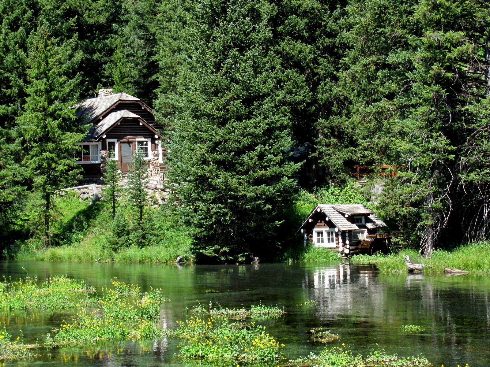
The cabin along side Big Springs was hand built by Johnny Sack.  Born in 1884, Johnny came to the United States with his parents and four brothers and sisters from Germany when he was six years old.  The family settled in South Bend, Indiana, and Johnny eventually made his way west to the newly established community of Ashton, Idaho.

Along with his brother Andy, Johnny arrived in Island Park by passenger train during a blizzard in June, 1909.
The brother's had wanted to raise cattle on Henrys
Lake Flat.  After years of working for various ranchers and serving time in the military, Johnny began making his living building furniture and cabins.

Standing just four foot, eleven inches tall, Johnny leased his cabin site land from the United States Forest Service and began building his two story log cabin.  Little did Johnny know when he first acquired the choice building site, his home would become a landmark one day discussed in the United States Congress.

Due to its unique location and picturesque setting, Johnny's cabin and nearby water-wheel have long been one of the most photographed sites in Island Park.

The statue of Johnny and his dog was carved from a
log that was found near the water-wheel.

The cabin took Johnny approximately three years to complete, as Johnny worked primarily with hand tools - saws, draw knives, scrapers and planers.  Johnny built a small structure and water wheel at the edge of the springs to harness the power of the springs and create electricity.

From his cabin overlooking Big Springs, the headwaters of the Henrys Fork of the Snake River, Johnny welcomed visitors from all over the world who stopped by to look at his charming cabin and nearby water-wheel.  Much like today, visitors were welcomed in and shown about the unique structure.

After his death in 1957 the cabin became the property of Johnny's two sisters.  They later sold the cabin to Elberta and Rudy Kipp, who made it possible for the building to be opened as an interpretive center in 1980.

The cabin became part of the National Register of Historic Places in 1979 and is the property of the USFS.  The cabin remains open to the visitors through the efforts of the USFS,  Fremont County Parks and Recreation, the Island Park Historical Society, and numerous volunteers.

 What a lovely place!!!!

More from Island Park later,

Candy and Johnny
Posted by Picasa