Monday, July 29, 2013

2013 July: Sweet Creek Falls

 Sweet Creek Falls is a gem of a hike, nestled in the hills between Mapleton and Eugene, Oregon and is part of the Suislaw National Forest.  The total hike is a fairly easy 3.8 miles round trip, with only a 500 foot elevation gain.  The trail head is a little difficult to find and there are not a lot of signs to direct you to the parking area.

It was a beautiful hike, with ferns of all sizes and mosses of amazing shades of green covering the trees and downed logs.

As you walk upstream, there are several small waterfalls cascading over rocks.  At the end of the trail is where Sweet Creek Falls cascades
 seventy-five feet into a pristine blue pool.

What a beautiful hike in the woods, well worth the drive!!

Until Later.
Candy and Johnny along the road.


Posted by Picasa

2013 July; Trip to Angess


 It was a sunny Sunday and John decided that we should take a drive up along the Rogue River to the town of Agness.  We drove through the town of Gold Beach, just before the I.L.Patterson Memorial Bridge (which was the first in the country to be built with prestressed concrete in 1931.  It has seven arches of reinforced concrete), we took a right turn and headed to Agness.

Agness is an unincorporated community in Curry County, Oregon.  It is located near the confluence of two Wild and Scenic rivers - the Lower Rogue and the Illinois.  Agness post office was named after Agnes, the daughter of the first postmaster, and subsequently misspelled.  The Agness area is popular for fishing and hiking.  Agness is in the rogue River Siskiyou National Forest and was threatened by the Biscuit Fire in 2002.

Agness is known because it is served by one of only two rural mail boat routes still operating in the U.S.  The other is along the Snake River in eastern Oregon.  The mail boat runs on the Rogue River between Gold Beach and Agness.

Agness has a kindergarten-sixth grade "one room school", which actually consists of two rooms.  It is kept open by the Central Curry School District
because of its 'geographicial remoteness":  approximately 30 miles from gold Beach up a "winding and sometimes dangerous" road.  This road (County Road 595) is a continuation of Bear Camp Road, which had been the site of several incidents that have resulted in the deaths of travelers. (Glad I did not know this before we left!)

Much of Agness's economy is based on tourism.  There are several lodges and camping sites along the river.  Many cater to the large jet boats from Jerry's Rogue Jest which carry up to 50 passengers from Gold Beach to various locations in the Rogue Valley.

All we could find was this sign!! and one of the lodges, a General Store and the small school house.

One of those out of the way places that not many people find along the roads travelled.

Until later,  Candy and Johnny

Posted by Picasa

Friday, July 26, 2013

2013 July: Drive through Tree

 One of the most famous trees in the world,
 the Wawona Tree, also known as the Wawona Tunnel Tree was a famous giant sequoia that stood in Mariposa Grove, Yosemite National Park until 1969.  It had a height of 227 feet and 90 feet in circumference.  It has appeared in portrait from travel brochures and geography texts the world over.

The tunnel was cut through the tree in 1881, enlarging an existing fire scar.  The Yosemite Stage and Turnpike Company paid the Scribner brothers $75 to enlarge the burn scar to the tunnel size of 6 1/2 - 8 feet wide, 9 feet high and 26 feet long.  The tree also became a popular tourist attraction and visitors were often photographed driving through or standing in the tunnel.

The Wawona Tree fell in 1969 under a heavy load of snow on its crown.  The giant sequoia is estimated to have been 2,300 years old.

We did not see the tree but had hear the stories of "drive through" trees. When visiting the  Redwood Forest National Park Center, I enquired about drive through or tunnel trees and was informed that the National Park service does not endorse the drive through trees, however there was one such tree along the Redwood Highway located on private land.

 We decided to investigate, and we found it in Klamath, California. 
This privately owned tourist attraction was created for the benefit of those people who desire the unique experience of driving through a healthy, living Redwood tree.
The Tour-Thur Tree is approximately 785 years old and, at some time in the distant past was scarred by fire.  The tree, because of it's giant size was spared, along with neighboring trees, when the area was logged in 1967.  The tunnel through the tree was completed in May, 1976, and opened to the public the following month.

The opening in 7'4" wide and 9'6" high, permitting the passage of all standard cars, vans and pickups.

The tree is 17 feet in diameter at eye level.  It is about 90 feet tall to the point where the top was blown off.  Side branches give an overall height of 183 feet.

You can John in the car driving through the tree.

One of those "tourist" things to do!?!!

See more about the Redwoods in the blog below.

More later, 

Candy and Johnny
Posted by Picasa

2013 July; Giant Redwood National Park

 As you drive along Highway 101 along the California/Oregon Coast, you may not ever realize that you are driving in the Redwoods National/ State Park.  There is no ranger entry station or entry fee, just an impressive sight of tall trees.

The Redwood National and State Parks are located along the narrow corridor of California's northern coast, the world's tallest trees reign over a fog-shrouded domain.  The parks, comprising the Redwood National park (established 1968) and California's Del Norte Coast, Jedediah Smith and Prairie Creek Redwoods State Parks (dating from the 1920's) contain 133,000 acres.  Located entirely within Del Norte and Humboldt Counties, the four parks, together, protect 45% of all remaining redwood old-growth forests, totaling at least 38,982 acres.  These trees are the tallest and one of the most massive tree species on Earth. Within an elevation range from sea level to 3,200 feet a delightful array of scenes invites visitors to experience the splendor of this special place.

Standing at the base of one of these lofty monarch, one may be overwhelmed by the presence of a tree whose crown is not visible.

Some redwood are taller than a football field is long; many exceed the height of the Statue of Liberty or a 30 story building.

These venerable giants may live a thousand or more years, but the average of a virgin redwood in 500 to 700 years.  The oldest known individual, felled long ago, was more than 2,200 years old.


 When logging began in 1850, roughly 2,000,000 acres of ancient or "old growth" coast redwoods forest canopy mantled the coastal Mountains of California. After many decades of unobstructed clear-cut logging, serious efforts toward conservation began. Today, just about 10% remains.  It wasn't until the early 1960's that a movement for a national park generated support to begin to save these tall giants.  About 50,000 acres of the remaining 300,000 acres are located within the National and State Park system.


 The drive along Highway 101 and also the Howland Hill Road that navigates through the Jedediah Smith Redwoods State Park, is very impressive.  What an awe-inspiring place!

Makes you feel rather small.

Until later,
Candy and Johnny along the road.
Posted by Picasa

Wednesday, July 24, 2013

2013 July 15; Bodie Ghost Town


 Located northeast of Yosemite National Park on S.R. 270 is the historic gold mining town of Bodie, home to one of the richest gold strikes in California.  This was once known as the most lawless and toughest mining camp in the West.  To walk the streets of this ghost town and peer into the windows of the remaining homes, businesses and sites is to be transported back to the days when Bodie was a thriving mining town.

Bodie is 13 miles east of Highway 395, the last 3 miles to the park is a very rough dirt road.  The town sits at an elevation of 8,375 feet.

The town of Bodie was named after Waterman S. Body, who discovered gold here in 1859.  The change in spelling of the town's name has often been attributed to an illiterate sign painter, but it was a deliberate change by the citizenry to ensure proper pronunciation.

In 1859 W.S. Bodey and E. S. "Black" Taylor stumbled upon one of the richest gold strikes.  The ore extracted from the Bodie Hills amounted to millions in gold and silver.  Unfortunately, Bodey was not able to enjoy his discovery - he froze to death in a blizzard while returning with supplies in November 1859.

Bodie faded into a ghost town during the 1940's.
  In 1962 the small part of the town that had
survived the 1932 fire was designated a State
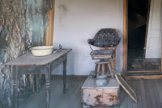
 Historic Park and a National Historic Landmark. What remains of the town of Bodie, preserved in a state of "arrested decay," exists as it did when the last residents left.  The interiors are maintained as they were left, still furnished and stocked with goods, providing a snapshot of the past.

Some say that the town is cursed.  There are postings to please leave all artifacts where they lie. Nothing is to be removed from the area.  Some say that removing items will bring bad luck to those removing items.  This may be true as almost every day the Park Service receives items being returned in the mail to Bodie, with notes apologizing for  having removed such items, and hope that their luck will change.


 It was a bit eerie peering into the windows and seeing how things were left when the people left Bodie.

Another interesting find along the way!

Until later,  Candy and Johnny


Posted by Picasa

Monday, July 22, 2013

2013 July 14: Yosemite National Park

 Yosemite National Park was set aside as a national park on October 1, 1890, to preserve natural scenery unmatched anywhere.  It has three major features - High Sierra wild lands, groves of giant sequoias, and Yosemite Valley.  The park covers approximately 1200 square miles of wilderness in the Sierra Nevada Mountains in central California.  The  park is roughly the size of Rhode Island and is a United Nations World Heritage site.  The park has innumerable lakes, meadows, forests and granite summits with endless unspoiled scenery.  At the center is Yosemite Valley a half mile deep depression carved by glaciers during the last ice-age.  It has 3,000 foot high domes and many powerful waterfalls,
 including three of the world's highest.

Bridalveil Falls plunges 620 feet and runs all year, though it diminishes in late summer.  The wind often blows the falls sideways giving it the appearance of a "brides veil".

Yosemite Falls, one of the world's highest waterfalls.  Its 2,425 foot total drop is divided into the great Upper Fall (1,430 feet), a middle cascade (675 feet), and the Lower Fall (320 feet) which itself is twice the height of Niagara.  The falls fill the Valley with their thunder in the spring and early summer when the winter snows have begun to melt, but they usually run dry in late summer and autumn after the water source has disappeared.

We entered the park from the Lee Vining Canyon from the east off Highway 395.  We turned onto Highway 120, the Tioga Pass/Yosemite National Park turnoff.  The road climbs through a steep canyon, affording incredible views of the rugged landscape.  We finally reached the entrance to the park at a height of 9,945 feet.  This road is closed in winter, and it was easy to see why.  We only spent one day in the Park but there is so much more to see!!  Maybe someday a return visit.

The photo's really do not do the park justice....

More later,  Candy and Johnny


Posted by Picasa